You are here: Home > Network List > YB13 - Continental Dynamics/Cent. Anatolian Tectonics:Surface to Mantle Dynamics During Stations List
> Station AT49 Kolukisa,Konya,Turkey > Earthquake Result Viewer
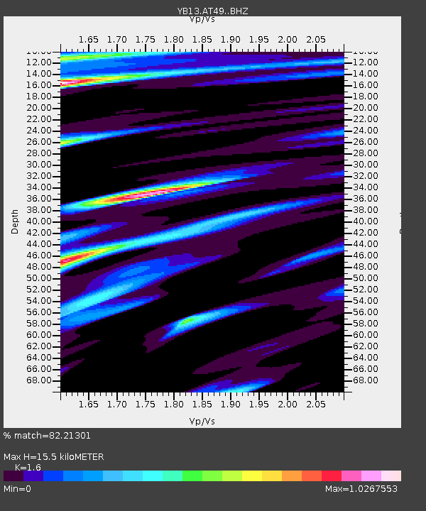
AT49 Kolukisa,Konya,Turkey - Earthquake Result Viewer
| Earthquake location: |
Iceland |
| Earthquake latitude/longitude: |
64.7/-17.3 |
| Earthquake time(UTC): |
2014/08/29 (241) 12:21:49 GMT |
| Earthquake Depth: |
10 km |
| Earthquake Magnitude: |
5.3 MW, 5.2 mb, 5.4 Mww |
| Earthquake Catalog/Contributor: |
ISC/ISC |
|
| Network: |
YB Continental Dynamics/Cent. Anatolian Tectonics:Surface to Mantle Dynamics During |
| Station: |
AT49 Kolukisa,Konya,Turkey |
| Lat/Lon: |
38.51 N/32.25 E |
| Elevation: |
1036 m |
|
| Distance: |
38.9 deg |
| Az: |
107.901 deg |
| Baz: |
328.614 deg |
| Ray Param: |
0.07530239 |
| Estimated Moho Depth: |
15.5 km |
| Estimated Crust Vp/Vs: |
1.60 |
| Assumed Crust Vp: |
6.159 km/s |
| Estimated Crust Vs: |
3.849 km/s |
| Estimated Crust Poisson's Ratio: |
0.18 |
|
| Radial Match: |
82.21301 % |
| Radial Bump: |
400 |
| Transverse Match: |
65.16171 % |
| Transverse Bump: |
382 |
| SOD ConfigId: |
3390531 |
| Insert Time: |
2019-04-13 17:14:14.051 +0000 |
| GWidth: |
2.5 |
| Max Bumps: |
400 |
| Tol: |
0.001 |
|

Signal To Noise
| Channel | StoN | STA | LTA |
| YB:AT49: :BHZ:20140829T12:28:44.020002Z | 6.0999503 | 4.6466636E-7 | 7.617543E-8 |
| YB:AT49: :BHN:20140829T12:28:44.020002Z | 2.6315477 | 1.8257617E-7 | 6.9379766E-8 |
| YB:AT49: :BHE:20140829T12:28:44.020002Z | 3.440342 | 3.1750358E-7 | 9.228838E-8 |
| Arrivals |
| Ps | 1.6 SECOND |
| PpPs | 6.1 SECOND |
| PsPs/PpSs | 7.7 SECOND |


