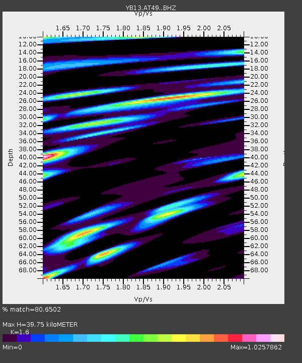
AT49 Kolukisa,Konya,Turkey - Earthquake Result Viewer

Earthquake location: Southeast Of Honshu, Japan
Earthquake latitude/longitude: 31.7/140.5
Earthquake time(UTC): 2014/10/15 (288) 23:53:01 GMT
Earthquake Depth: 58 km
Earthquake Magnitude: 5.5 MWW, 5.5 MWC, 5.6 MWB
Earthquake Catalog/Contributor: NEIC PDE/NEIC COMCAT
Network: YB Continental Dynamics/Cent. Anatolian Tectonics:Surface to Mantle Dynamics During
Station: AT49 Kolukisa,Konya,Turkey
Lat/Lon: 38.51 N/32.25 E
Elevation: 1036 m
Distance: 83.4 deg
Az: 311.412 deg
Baz: 54.535 deg
Ray Param: 0.04612223
Estimated Moho Depth: 39.75 km
Estimated Crust Vp/Vs: 1.60
Assumed Crust Vp: 6.159 km/s
Estimated Crust Vs: 3.849 km/s
Estimated Crust Poisson's Ratio: 0.18
Radial Match: 80.6502 %
Radial Bump: 400
Transverse Match: 79.32691 %
Transverse Bump: 400
SOD ConfigId: 3390531
Insert Time: 2019-04-14 14:17:03.812 +0000
GWidth: 2.5
Max Bumps: 400
Tol: 0.001

Signal To Noise

ChannelStoNSTALTA
YB:AT49: :BHZ:20141016T00:04:51.380015Z21.4354978.643027E-74.0321094E-8
YB:AT49: :BHN:20141016T00:04:51.380015Z8.0796562.534948E-73.1374455E-8
YB:AT49: :BHE:20141016T00:04:51.380015Z4.89162353.063968E-76.2637035E-8
Arrivals
Ps4.0 SECOND
PpPs16 SECOND
PsPs/PpSs20 SECOND