You are here: Home > Network List > YB13 - Continental Dynamics/Cent. Anatolian Tectonics:Surface to Mantle Dynamics During Stations List
> Station AT49 Kolukisa,Konya,Turkey > Earthquake Result Viewer
AT49 Kolukisa,Konya,Turkey - Earthquake Result Viewer
| Earthquake location: |
Iceland |
| Earthquake latitude/longitude: |
64.6/-17.2 |
| Earthquake time(UTC): |
2014/11/02 (306) 16:05:46 GMT |
| Earthquake Depth: |
9.0 km |
| Earthquake Magnitude: |
5.4 MW, 5.1 mb, 4.9 MS |
| Earthquake Catalog/Contributor: |
ISC/ISC |
|
| Network: |
YB Continental Dynamics/Cent. Anatolian Tectonics:Surface to Mantle Dynamics During |
| Station: |
AT49 Kolukisa,Konya,Turkey |
| Lat/Lon: |
38.51 N/32.25 E |
| Elevation: |
1036 m |
|
| Distance: |
38.8 deg |
| Az: |
107.873 deg |
| Baz: |
328.434 deg |
| Ray Param: |
0.07535845 |
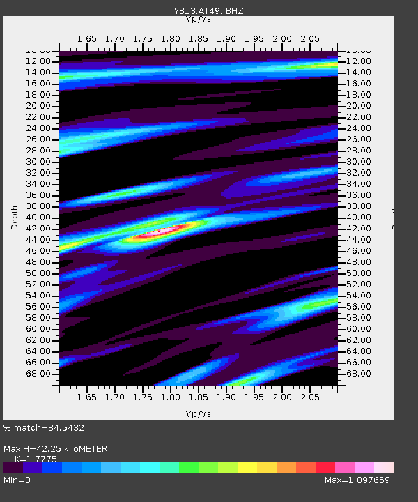
| Estimated Moho Depth: |
42.25 km |
| Estimated Crust Vp/Vs: |
1.78 |
| Assumed Crust Vp: |
6.159 km/s |
| Estimated Crust Vs: |
3.465 km/s |
| Estimated Crust Poisson's Ratio: |
0.27 |
|
| Radial Match: |
84.5432 % |
| Radial Bump: |
314 |
| Transverse Match: |
63.237274 % |
| Transverse Bump: |
400 |
| SOD ConfigId: |
3390531 |
| Insert Time: |
2019-04-14 20:13:06.849 +0000 |
| GWidth: |
2.5 |
| Max Bumps: |
400 |
| Tol: |
0.001 |
|

Signal To Noise
| Channel | StoN | STA | LTA |
| YB:AT49: :BHZ:20141102T16:12:40.320007Z | 3.4821944 | 3.2681075E-7 | 9.385195E-8 |
| YB:AT49: :BHN:20141102T16:12:40.320007Z | 1.592751 | 1.3172567E-7 | 8.270324E-8 |
| YB:AT49: :BHE:20141102T16:12:40.320007Z | 1.917656 | 1.8186425E-7 | 9.483674E-8 |
| Arrivals |
| Ps | 5.7 SECOND |
| PpPs | 18 SECOND |
| PsPs/PpSs | 24 SECOND |


