You are here: Home > Network List > YB13 - Continental Dynamics/Cent. Anatolian Tectonics:Surface to Mantle Dynamics During Stations List
> Station AT49 Kolukisa,Konya,Turkey > Earthquake Result Viewer
AT49 Kolukisa,Konya,Turkey - Earthquake Result Viewer
| Earthquake location: |
Northern Molucca Sea |
| Earthquake latitude/longitude: |
1.9/126.5 |
| Earthquake time(UTC): |
2014/11/15 (319) 02:31:40 GMT |
| Earthquake Depth: |
35 km |
| Earthquake Magnitude: |
7.1 MWW, 7.0 MWW, 7.3 MI |
| Earthquake Catalog/Contributor: |
NEIC PDE/NEIC COMCAT |
|
| Network: |
YB Continental Dynamics/Cent. Anatolian Tectonics:Surface to Mantle Dynamics During |
| Station: |
AT49 Kolukisa,Konya,Turkey |
| Lat/Lon: |
38.51 N/32.25 E |
| Elevation: |
1036 m |
|
| Distance: |
92.2 deg |
| Az: |
308.477 deg |
| Baz: |
85.832 deg |
| Ray Param: |
0.041488595 |
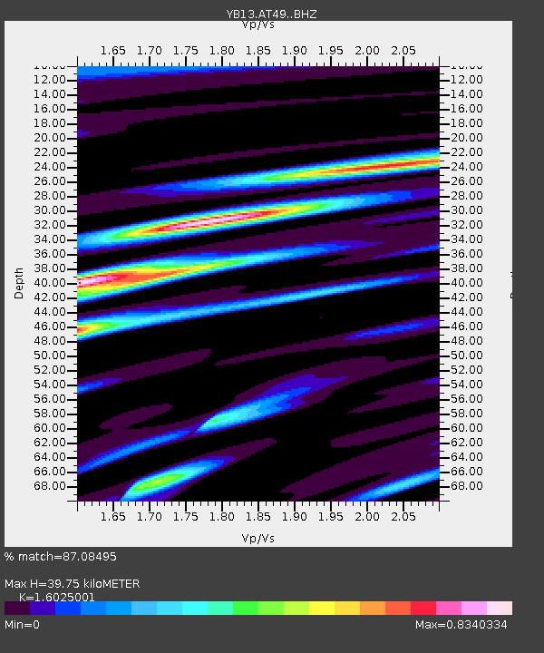
| Estimated Moho Depth: |
39.75 km |
| Estimated Crust Vp/Vs: |
1.60 |
| Assumed Crust Vp: |
6.159 km/s |
| Estimated Crust Vs: |
3.843 km/s |
| Estimated Crust Poisson's Ratio: |
0.18 |
|
| Radial Match: |
87.08495 % |
| Radial Bump: |
400 |
| Transverse Match: |
85.45939 % |
| Transverse Bump: |
400 |
| SOD ConfigId: |
3390531 |
| Insert Time: |
2019-04-15 00:12:37.277 +0000 |
| GWidth: |
2.5 |
| Max Bumps: |
400 |
| Tol: |
0.001 |
|

Signal To Noise
| Channel | StoN | STA | LTA |
| YB:AT49: :BHZ:20141115T02:44:15.398982Z | 12.054793 | 1.307916E-6 | 1.0849759E-7 |
| YB:AT49: :BHN:20141115T02:44:15.398982Z | 1.9529902 | 1.8838269E-7 | 9.645859E-8 |
| YB:AT49: :BHE:20141115T02:44:15.398982Z | 4.7793283 | 4.633146E-7 | 9.6941356E-8 |
| Arrivals |
| Ps | 4.0 SECOND |
| PpPs | 16 SECOND |
| PsPs/PpSs | 20 SECOND |


