You are here: Home > Network List > YB13 - Continental Dynamics/Cent. Anatolian Tectonics:Surface to Mantle Dynamics During Stations List
> Station AT49 Kolukisa,Konya,Turkey > Earthquake Result Viewer
AT49 Kolukisa,Konya,Turkey - Earthquake Result Viewer
| Earthquake location: |
Carlsberg Ridge |
| Earthquake latitude/longitude: |
6.0/61.3 |
| Earthquake time(UTC): |
2014/12/02 (336) 04:53:46 GMT |
| Earthquake Depth: |
10 km |
| Earthquake Magnitude: |
5.8 MB |
| Earthquake Catalog/Contributor: |
NEIC PDE/NEIC ALERT |
|
| Network: |
YB Continental Dynamics/Cent. Anatolian Tectonics:Surface to Mantle Dynamics During |
| Station: |
AT49 Kolukisa,Konya,Turkey |
| Lat/Lon: |
38.51 N/32.25 E |
| Elevation: |
1036 m |
|
| Distance: |
41.7 deg |
| Az: |
325.067 deg |
| Baz: |
133.448 deg |
| Ray Param: |
0.07360714 |
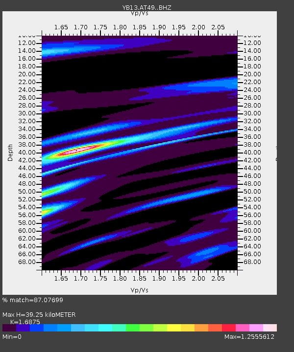
| Estimated Moho Depth: |
39.25 km |
| Estimated Crust Vp/Vs: |
1.69 |
| Assumed Crust Vp: |
6.159 km/s |
| Estimated Crust Vs: |
3.65 km/s |
| Estimated Crust Poisson's Ratio: |
0.23 |
|
| Radial Match: |
87.07699 % |
| Radial Bump: |
400 |
| Transverse Match: |
64.455246 % |
| Transverse Bump: |
400 |
| SOD ConfigId: |
3390531 |
| Insert Time: |
2019-04-15 07:14:33.130 +0000 |
| GWidth: |
2.5 |
| Max Bumps: |
400 |
| Tol: |
0.001 |
|

Signal To Noise
| Channel | StoN | STA | LTA |
| YB:AT49: :BHZ:20141202T05:01:03.279993Z | 13.174692 | 6.873563E-7 | 5.2172478E-8 |
| YB:AT49: :BHN:20141202T05:01:03.279993Z | 1.6403987 | 1.3257632E-7 | 8.081957E-8 |
| YB:AT49: :BHE:20141202T05:01:03.279993Z | 2.4724703 | 1.8726713E-7 | 7.57409E-8 |
| Arrivals |
| Ps | 4.7 SECOND |
| PpPs | 16 SECOND |
| PsPs/PpSs | 21 SECOND |


