You are here: Home > Network List > YB13 - Continental Dynamics/Cent. Anatolian Tectonics:Surface to Mantle Dynamics During Stations List
> Station AT49 Kolukisa,Konya,Turkey > Earthquake Result Viewer
AT49 Kolukisa,Konya,Turkey - Earthquake Result Viewer
| Earthquake location: |
Iceland |
| Earthquake latitude/longitude: |
64.6/-17.3 |
| Earthquake time(UTC): |
2014/12/05 (339) 21:04:58 GMT |
| Earthquake Depth: |
0.2 km |
| Earthquake Magnitude: |
5.4 MW, 5.2 mb, 5.4 Mww, 5.4 Mwc |
| Earthquake Catalog/Contributor: |
ISC/ISC |
|
| Network: |
YB Continental Dynamics/Cent. Anatolian Tectonics:Surface to Mantle Dynamics During |
| Station: |
AT49 Kolukisa,Konya,Turkey |
| Lat/Lon: |
38.51 N/32.25 E |
| Elevation: |
1036 m |
|
| Distance: |
38.8 deg |
| Az: |
107.737 deg |
| Baz: |
328.365 deg |
| Ray Param: |
0.075364925 |
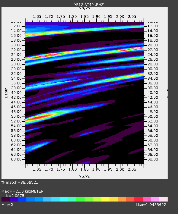
| Estimated Moho Depth: |
21.0 km |
| Estimated Crust Vp/Vs: |
2.09 |
| Assumed Crust Vp: |
6.159 km/s |
| Estimated Crust Vs: |
2.95 km/s |
| Estimated Crust Poisson's Ratio: |
0.35 |
|
| Radial Match: |
86.06521 % |
| Radial Bump: |
348 |
| Transverse Match: |
74.53042 % |
| Transverse Bump: |
400 |
| SOD ConfigId: |
3390531 |
| Insert Time: |
2019-04-15 09:01:05.877 +0000 |
| GWidth: |
2.5 |
| Max Bumps: |
400 |
| Tol: |
0.001 |
|

Signal To Noise
| Channel | StoN | STA | LTA |
| YB:AT49: :BHZ:20141205T21:11:53.920004Z | 6.757617 | 4.9762275E-7 | 7.363879E-8 |
| YB:AT49: :BHN:20141205T21:11:53.920004Z | 1.945376 | 1.789295E-7 | 9.1976815E-8 |
| YB:AT49: :BHE:20141205T21:11:53.920004Z | 2.429684 | 2.443845E-7 | 1.0058283E-7 |
| Arrivals |
| Ps | 3.9 SECOND |
| PpPs | 10.0 SECOND |
| PsPs/PpSs | 14 SECOND |


