You are here: Home > Network List > YB13 - Continental Dynamics/Cent. Anatolian Tectonics:Surface to Mantle Dynamics During Stations List
> Station AT49 Kolukisa,Konya,Turkey > Earthquake Result Viewer
AT49 Kolukisa,Konya,Turkey - Earthquake Result Viewer
| Earthquake location: |
Taiwan Region |
| Earthquake latitude/longitude: |
25.6/122.4 |
| Earthquake time(UTC): |
2014/12/10 (344) 21:03:39 GMT |
| Earthquake Depth: |
254 km |
| Earthquake Magnitude: |
6.1 MWB |
| Earthquake Catalog/Contributor: |
NEIC PDE/NEIC COMCAT |
|
| Network: |
YB Continental Dynamics/Cent. Anatolian Tectonics:Surface to Mantle Dynamics During |
| Station: |
AT49 Kolukisa,Konya,Turkey |
| Lat/Lon: |
38.51 N/32.25 E |
| Elevation: |
1036 m |
|
| Distance: |
74.7 deg |
| Az: |
305.582 deg |
| Baz: |
69.447 deg |
| Ray Param: |
0.05146108 |
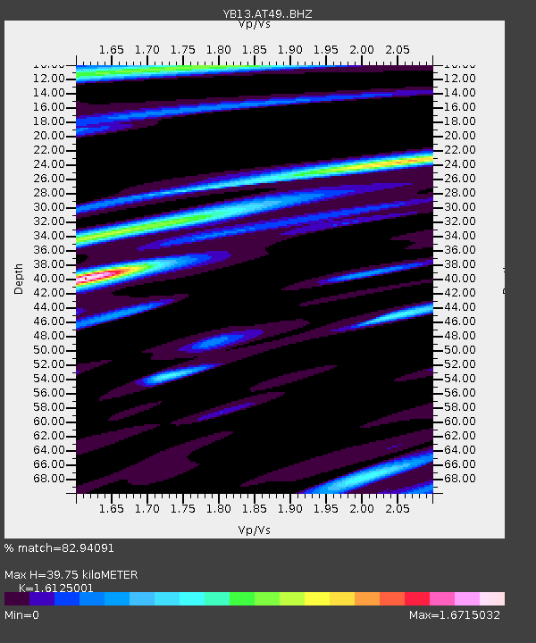
| Estimated Moho Depth: |
39.75 km |
| Estimated Crust Vp/Vs: |
1.61 |
| Assumed Crust Vp: |
6.159 km/s |
| Estimated Crust Vs: |
3.819 km/s |
| Estimated Crust Poisson's Ratio: |
0.19 |
|
| Radial Match: |
82.94091 % |
| Radial Bump: |
314 |
| Transverse Match: |
75.30834 % |
| Transverse Bump: |
390 |
| SOD ConfigId: |
3390531 |
| Insert Time: |
2019-04-15 12:17:14.527 +0000 |
| GWidth: |
2.5 |
| Max Bumps: |
400 |
| Tol: |
0.001 |
|

Signal To Noise
| Channel | StoN | STA | LTA |
| YB:AT49: :BHZ:20141210T21:14:19.979988Z | 18.189964 | 3.4191035E-6 | 1.8796649E-7 |
| YB:AT49: :BHN:20141210T21:14:19.979988Z | 3.3925104 | 6.9126764E-7 | 2.0376287E-7 |
| YB:AT49: :BHE:20141210T21:14:19.979988Z | 7.3118024 | 1.0729783E-6 | 1.4674607E-7 |
| Arrivals |
| Ps | 4.1 SECOND |
| PpPs | 16 SECOND |
| PsPs/PpSs | 20 SECOND |


