You are here: Home > Network List > YB13 - Continental Dynamics/Cent. Anatolian Tectonics:Surface to Mantle Dynamics During Stations List
> Station AT49 Kolukisa,Konya,Turkey > Earthquake Result Viewer
AT49 Kolukisa,Konya,Turkey - Earthquake Result Viewer
| Earthquake location: |
Mid-Indian Ridge |
| Earthquake latitude/longitude: |
-15.4/67.2 |
| Earthquake time(UTC): |
2015/05/05 (125) 20:53:21 GMT |
| Earthquake Depth: |
13 km |
| Earthquake Magnitude: |
5.4 MW |
| Earthquake Catalog/Contributor: |
ISC/ISC |
|
| Network: |
YB Continental Dynamics/Cent. Anatolian Tectonics:Surface to Mantle Dynamics During |
| Station: |
AT49 Kolukisa,Konya,Turkey |
| Lat/Lon: |
38.51 N/32.25 E |
| Elevation: |
1036 m |
|
| Distance: |
62.8 deg |
| Az: |
329.664 deg |
| Baz: |
141.614 deg |
| Ray Param: |
0.059954047 |
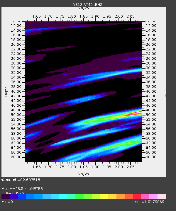
| Estimated Moho Depth: |
48.5 km |
| Estimated Crust Vp/Vs: |
2.10 |
| Assumed Crust Vp: |
6.159 km/s |
| Estimated Crust Vs: |
2.936 km/s |
| Estimated Crust Poisson's Ratio: |
0.35 |
|
| Radial Match: |
82.687515 % |
| Radial Bump: |
301 |
| Transverse Match: |
80.582405 % |
| Transverse Bump: |
379 |
| SOD ConfigId: |
7422571 |
| Insert Time: |
2019-04-18 16:53:23.719 +0000 |
| GWidth: |
2.5 |
| Max Bumps: |
400 |
| Tol: |
0.001 |
|

Signal To Noise
| Channel | StoN | STA | LTA |
| YB:AT49: :BHZ:20150505T21:03:16.099976Z | 10.318544 | 3.9217727E-7 | 3.8007034E-8 |
| YB:AT49: :BHN:20150505T21:03:16.099976Z | 1.2352772 | 7.157869E-8 | 5.794545E-8 |
| YB:AT49: :BHE:20150505T21:03:16.099976Z | 1.7589394 | 9.796174E-8 | 5.569364E-8 |
| Arrivals |
| Ps | 8.9 SECOND |
| PpPs | 24 SECOND |
| PsPs/PpSs | 33 SECOND |


