You are here: Home > Network List > YB13 - Continental Dynamics/Cent. Anatolian Tectonics:Surface to Mantle Dynamics During Stations List
> Station AT49 Kolukisa,Konya,Turkey > Earthquake Result Viewer
AT49 Kolukisa,Konya,Turkey - Earthquake Result Viewer
| Earthquake location: |
Mid-Indian Ridge |
| Earthquake latitude/longitude: |
-7.8/67.8 |
| Earthquake time(UTC): |
2015/05/11 (131) 17:42:03 GMT |
| Earthquake Depth: |
15 km |
| Earthquake Magnitude: |
5.3 MW, 4.7 MS, 5.2 mb |
| Earthquake Catalog/Contributor: |
ISC/ISC |
|
| Network: |
YB Continental Dynamics/Cent. Anatolian Tectonics:Surface to Mantle Dynamics During |
| Station: |
AT49 Kolukisa,Konya,Turkey |
| Lat/Lon: |
38.51 N/32.25 E |
| Elevation: |
1036 m |
|
| Distance: |
56.7 deg |
| Az: |
326.924 deg |
| Baz: |
136.422 deg |
| Ray Param: |
0.06394989 |
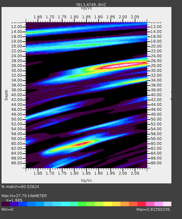
| Estimated Moho Depth: |
27.75 km |
| Estimated Crust Vp/Vs: |
1.99 |
| Assumed Crust Vp: |
6.159 km/s |
| Estimated Crust Vs: |
3.103 km/s |
| Estimated Crust Poisson's Ratio: |
0.33 |
|
| Radial Match: |
80.02624 % |
| Radial Bump: |
396 |
| Transverse Match: |
64.20067 % |
| Transverse Bump: |
400 |
| SOD ConfigId: |
7422571 |
| Insert Time: |
2019-04-18 19:53:36.701 +0000 |
| GWidth: |
2.5 |
| Max Bumps: |
400 |
| Tol: |
0.001 |
|

Signal To Noise
| Channel | StoN | STA | LTA |
| YB:AT49: :BHZ:20150511T17:51:15.12002Z | 12.048711 | 6.89083E-7 | 5.719143E-8 |
| YB:AT49: :BHN:20150511T17:51:15.12002Z | 1.7680701 | 1.3466797E-7 | 7.616665E-8 |
| YB:AT49: :BHE:20150511T17:51:15.12002Z | 1.8060709 | 1.5333895E-7 | 8.4901956E-8 |
| Arrivals |
| Ps | 4.6 SECOND |
| PpPs | 13 SECOND |
| PsPs/PpSs | 18 SECOND |


