You are here: Home > Network List > YB13 - Continental Dynamics/Cent. Anatolian Tectonics:Surface to Mantle Dynamics During Stations List
> Station AT49 Kolukisa,Konya,Turkey > Earthquake Result Viewer
AT49 Kolukisa,Konya,Turkey - Earthquake Result Viewer
| Earthquake location: |
Nepal |
| Earthquake latitude/longitude: |
27.8/86.1 |
| Earthquake time(UTC): |
2015/05/12 (132) 07:05:19 GMT |
| Earthquake Depth: |
15 km |
| Earthquake Magnitude: |
7.3 MWW |
| Earthquake Catalog/Contributor: |
NEIC PDE/NEIC COMCAT |
|
| Network: |
YB Continental Dynamics/Cent. Anatolian Tectonics:Surface to Mantle Dynamics During |
| Station: |
AT49 Kolukisa,Konya,Turkey |
| Lat/Lon: |
38.51 N/32.25 E |
| Elevation: |
1036 m |
|
| Distance: |
45.7 deg |
| Az: |
297.815 deg |
| Baz: |
86.778 deg |
| Ray Param: |
0.07107653 |
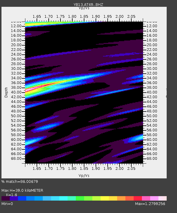
| Estimated Moho Depth: |
39.0 km |
| Estimated Crust Vp/Vs: |
1.60 |
| Assumed Crust Vp: |
6.159 km/s |
| Estimated Crust Vs: |
3.849 km/s |
| Estimated Crust Poisson's Ratio: |
0.18 |
|
| Radial Match: |
86.00679 % |
| Radial Bump: |
396 |
| Transverse Match: |
63.563595 % |
| Transverse Bump: |
400 |
| SOD ConfigId: |
7422571 |
| Insert Time: |
2019-04-18 20:13:43.974 +0000 |
| GWidth: |
2.5 |
| Max Bumps: |
400 |
| Tol: |
0.001 |
|

Signal To Noise
| Channel | StoN | STA | LTA |
| YB:AT49: :BHZ:20150512T07:13:09.200013Z | 54.37319 | 4.7281655E-6 | 8.695766E-8 |
| YB:AT49: :BHN:20150512T07:13:09.200013Z | 8.868604 | 6.220895E-7 | 7.014514E-8 |
| YB:AT49: :BHE:20150512T07:13:09.200013Z | 18.941462 | 1.971551E-6 | 1.0408653E-7 |
| Arrivals |
| Ps | 4.1 SECOND |
| PpPs | 15 SECOND |
| PsPs/PpSs | 19 SECOND |


