You are here: Home > Network List > HW - Hanford Washington Seismic Network Stations List
> Station PHIN Phinny Hill Vineyards, Prosser, WA, USA > Earthquake Result Viewer
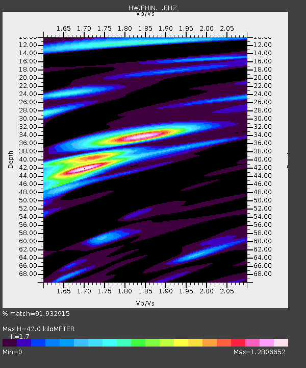
PHIN Phinny Hill Vineyards, Prosser, WA, USA - Earthquake Result Viewer
| Earthquake location: |
Southwestern Ryukyu Isl., Japan |
| Earthquake latitude/longitude: |
23.5/123.5 |
| Earthquake time(UTC): |
2009/08/17 (229) 00:05:49 GMT |
| Earthquake Depth: |
20 km |
| Earthquake Magnitude: |
6.2 MB, 6.6 MS, 6.7 MW, 6.6 MW |
| Earthquake Catalog/Contributor: |
WHDF/NEIC |
|
| Network: |
HW Hanford Washington Seismic Network |
| Station: |
PHIN Phinny Hill Vineyards, Prosser, WA, USA |
| Lat/Lon: |
45.90 N/119.93 W |
| Elevation: |
227 m |
|
| Distance: |
90.2 deg |
| Az: |
38.654 deg |
| Baz: |
304.81 deg |
| Ray Param: |
0.041690715 |
| Estimated Moho Depth: |
42.0 km |
| Estimated Crust Vp/Vs: |
1.70 |
| Assumed Crust Vp: |
6.571 km/s |
| Estimated Crust Vs: |
3.865 km/s |
| Estimated Crust Poisson's Ratio: |
0.24 |
|
| Radial Match: |
91.932915 % |
| Radial Bump: |
400 |
| Transverse Match: |
86.15409 % |
| Transverse Bump: |
400 |
| SOD ConfigId: |
2622 |
| Insert Time: |
2010-03-09 07:59:24.808 +0000 |
| GWidth: |
2.5 |
| Max Bumps: |
400 |
| Tol: |
0.001 |
|

Signal To Noise
| Channel | StoN | STA | LTA |
| HW:PHIN: :BHZ:20090817T00:18:16.30002Z | 4.6098647 | 2.836635E-7 | 6.153402E-8 |
| HW:PHIN: :BHN:20090817T00:18:16.30002Z | 0.8436366 | 5.6300834E-8 | 6.6735886E-8 |
| HW:PHIN: :BHE:20090817T00:18:16.30002Z | 2.3233333 | 9.394246E-8 | 4.0434347E-8 |
| Arrivals |
| Ps | 4.6 SECOND |
| PpPs | 17 SECOND |
| PsPs/PpSs | 21 SECOND |


