You are here: Home > Network List > HW - Hanford Washington Seismic Network Stations List
> Station PHIN Phinny Hill Vineyards, Prosser, WA, USA > Earthquake Result Viewer
PHIN Phinny Hill Vineyards, Prosser, WA, USA - Earthquake Result Viewer
| Earthquake location: |
New Britain Region, P.N.G. |
| Earthquake latitude/longitude: |
-6.0/150.4 |
| Earthquake time(UTC): |
2010/07/18 (199) 13:04:09 GMT |
| Earthquake Depth: |
28 km |
| Earthquake Magnitude: |
6.3 MB, 7.1 MS, 6.9 MW, 6.8 MW |
| Earthquake Catalog/Contributor: |
WHDF/NEIC |
|
| Network: |
HW Hanford Washington Seismic Network |
| Station: |
PHIN Phinny Hill Vineyards, Prosser, WA, USA |
| Lat/Lon: |
45.90 N/119.93 W |
| Elevation: |
227 m |
|
| Distance: |
94.0 deg |
| Az: |
44.432 deg |
| Baz: |
265.6 deg |
| Ray Param: |
0.04113801 |
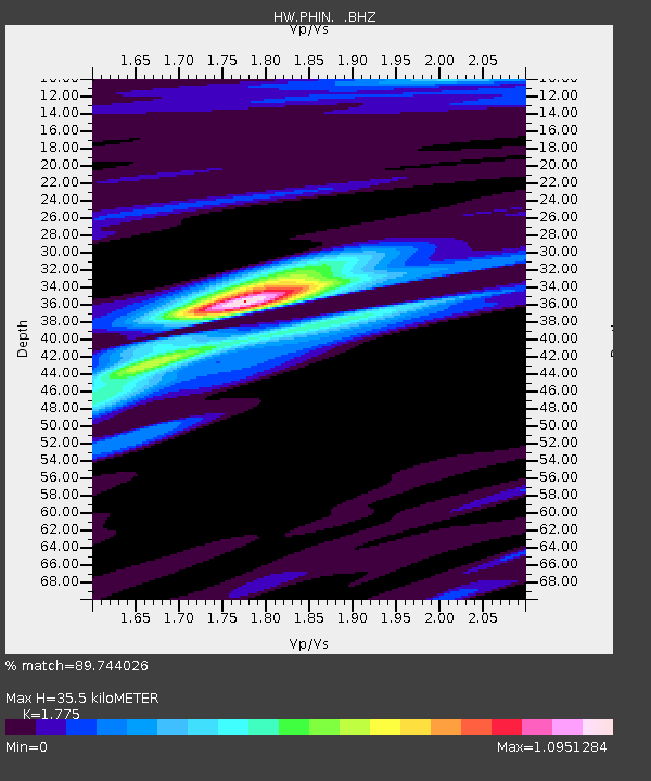
| Estimated Moho Depth: |
35.5 km |
| Estimated Crust Vp/Vs: |
1.77 |
| Assumed Crust Vp: |
6.571 km/s |
| Estimated Crust Vs: |
3.702 km/s |
| Estimated Crust Poisson's Ratio: |
0.27 |
|
| Radial Match: |
89.744026 % |
| Radial Bump: |
338 |
| Transverse Match: |
76.866684 % |
| Transverse Bump: |
400 |
| SOD ConfigId: |
319893 |
| Insert Time: |
2011-01-05 06:32:35.840 +0000 |
| GWidth: |
2.5 |
| Max Bumps: |
400 |
| Tol: |
0.001 |
|

Signal To Noise
| Channel | StoN | STA | LTA |
| HW:PHIN: :BHZ:20100718T13:16:53.225002Z | 16.757486 | 2.8508437E-6 | 1.7012358E-7 |
| HW:PHIN: :BHN:20100718T13:16:53.225002Z | 0.6247997 | 7.129305E-8 | 1.1410544E-7 |
| HW:PHIN: :BHE:20100718T13:16:53.225002Z | 7.4875593 | 7.461089E-7 | 9.964648E-8 |
| Arrivals |
| Ps | 4.3 SECOND |
| PpPs | 15 SECOND |
| PsPs/PpSs | 19 SECOND |


