You are here: Home > Network List > HW - Hanford Washington Seismic Network Stations List
> Station PHIN Phinny Hill Vineyards, Prosser, WA, USA > Earthquake Result Viewer
PHIN Phinny Hill Vineyards, Prosser, WA, USA - Earthquake Result Viewer
| Earthquake location: |
South Of Mariana Islands |
| Earthquake latitude/longitude: |
12.3/141.4 |
| Earthquake time(UTC): |
2010/08/14 (226) 23:01:04 GMT |
| Earthquake Depth: |
13 km |
| Earthquake Magnitude: |
6.1 MB, 6.3 MS, 6.6 MW, 6.3 MW |
| Earthquake Catalog/Contributor: |
WHDF/NEIC |
|
| Network: |
HW Hanford Washington Seismic Network |
| Station: |
PHIN Phinny Hill Vineyards, Prosser, WA, USA |
| Lat/Lon: |
45.90 N/119.93 W |
| Elevation: |
227 m |
|
| Distance: |
87.2 deg |
| Az: |
43.73 deg |
| Baz: |
284.651 deg |
| Ray Param: |
0.04347834 |
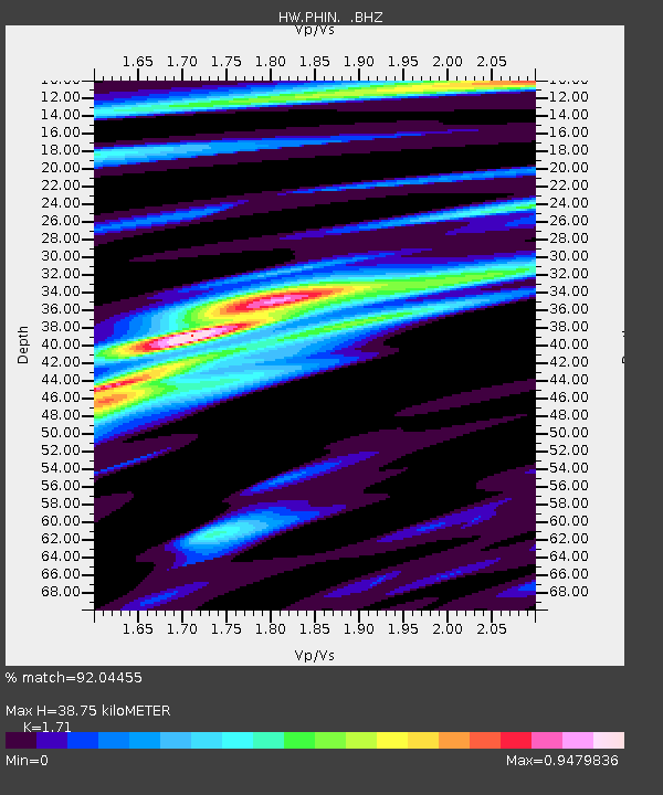
| Estimated Moho Depth: |
38.75 km |
| Estimated Crust Vp/Vs: |
1.71 |
| Assumed Crust Vp: |
6.571 km/s |
| Estimated Crust Vs: |
3.843 km/s |
| Estimated Crust Poisson's Ratio: |
0.24 |
|
| Radial Match: |
92.04455 % |
| Radial Bump: |
400 |
| Transverse Match: |
85.33638 % |
| Transverse Bump: |
400 |
| SOD ConfigId: |
319893 |
| Insert Time: |
2011-01-05 23:00:31.608 +0000 |
| GWidth: |
2.5 |
| Max Bumps: |
400 |
| Tol: |
0.001 |
|

Signal To Noise
| Channel | StoN | STA | LTA |
| HW:PHIN: :BHZ:20100814T23:13:18.47501Z | 7.288596 | 8.650312E-7 | 1.18682834E-7 |
| HW:PHIN: :BHN:20100814T23:13:18.47501Z | 1.0815102 | 8.1392635E-8 | 7.525831E-8 |
| HW:PHIN: :BHE:20100814T23:13:18.47501Z | 2.8409715 | 2.0739623E-7 | 7.300187E-8 |
| Arrivals |
| Ps | 4.3 SECOND |
| PpPs | 16 SECOND |
| PsPs/PpSs | 20 SECOND |


