You are here: Home > Network List > US - United States National Seismic Network Stations List
> Station HLID Hailey, Idaho, USA > Earthquake Result Viewer
HLID Hailey, Idaho, USA - Earthquake Result Viewer
| Earthquake location: |
Near Coast Of Ecuador |
| Earthquake latitude/longitude: |
-2.9/-79.8 |
| Earthquake time(UTC): |
2023/03/18 (077) 17:12:53 GMT |
| Earthquake Depth: |
66 km |
| Earthquake Magnitude: |
6.7 Mww |
| Earthquake Catalog/Contributor: |
NEIC PDE/us |
|
| Network: |
US United States National Seismic Network |
| Station: |
HLID Hailey, Idaho, USA |
| Lat/Lon: |
43.56 N/114.41 W |
| Elevation: |
1772 m |
|
| Distance: |
55.7 deg |
| Az: |
330.008 deg |
| Baz: |
136.621 deg |
| Ray Param: |
0.064462975 |
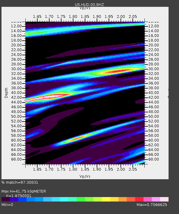
| Estimated Moho Depth: |
41.75 km |
| Estimated Crust Vp/Vs: |
1.68 |
| Assumed Crust Vp: |
6.291 km/s |
| Estimated Crust Vs: |
3.756 km/s |
| Estimated Crust Poisson's Ratio: |
0.22 |
|
| Radial Match: |
97.30831 % |
| Radial Bump: |
343 |
| Transverse Match: |
89.003586 % |
| Transverse Bump: |
400 |
| SOD ConfigId: |
34243671 |
| Insert Time: |
2024-05-03 09:29:07.658 +0000 |
| GWidth: |
2.5 |
| Max Bumps: |
400 |
| Tol: |
0.001 |
|

Signal To Noise
| Channel | StoN | STA | LTA |
| US:HLID:00:BHZ:20230318T17:21:50.950026Z | 6.933593 | 7.9324553E-7 | 1.14406134E-7 |
| US:HLID:00:BH1:20230318T17:21:50.950026Z | 2.9375472 | 2.9854115E-7 | 1.016294E-7 |
| US:HLID:00:BH2:20230318T17:21:50.950026Z | 2.6722584 | 2.5025457E-7 | 9.364909E-8 |
| Arrivals |
| Ps | 4.7 SECOND |
| PpPs | 17 SECOND |
| PsPs/PpSs | 22 SECOND |


