You are here: Home > Network List > HW - Hanford Washington Seismic Network Stations List
> Station PHIN Phinny Hill Vineyards, Prosser, WA, USA > Earthquake Result Viewer
PHIN Phinny Hill Vineyards, Prosser, WA, USA - Earthquake Result Viewer
| Earthquake location: |
Near East Coast Of Kamchatka |
| Earthquake latitude/longitude: |
55.9/162.1 |
| Earthquake time(UTC): |
2011/02/20 (051) 21:43:24 GMT |
| Earthquake Depth: |
33 km |
| Earthquake Magnitude: |
6.1 MB, 5.9 MS, 6.2 MW, 5.9 MW |
| Earthquake Catalog/Contributor: |
WHDF/NEIC |
|
| Network: |
HW Hanford Washington Seismic Network |
| Station: |
PHIN Phinny Hill Vineyards, Prosser, WA, USA |
| Lat/Lon: |
45.90 N/119.93 W |
| Elevation: |
227 m |
|
| Distance: |
47.7 deg |
| Az: |
67.531 deg |
| Baz: |
311.849 deg |
| Ray Param: |
0.0697878 |
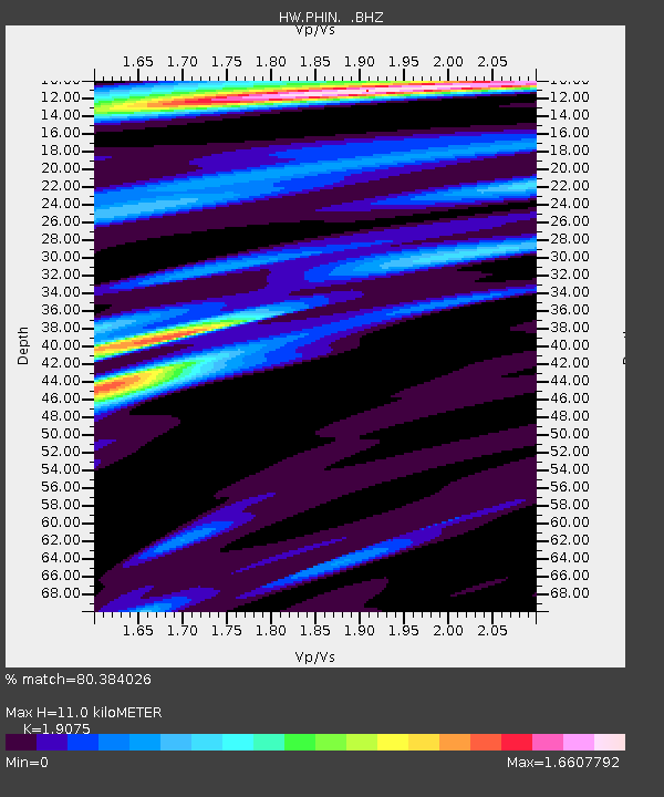
| Estimated Moho Depth: |
11.0 km |
| Estimated Crust Vp/Vs: |
1.91 |
| Assumed Crust Vp: |
6.571 km/s |
| Estimated Crust Vs: |
3.445 km/s |
| Estimated Crust Poisson's Ratio: |
0.31 |
|
| Radial Match: |
80.384026 % |
| Radial Bump: |
400 |
| Transverse Match: |
79.38672 % |
| Transverse Bump: |
400 |
| SOD ConfigId: |
353373 |
| Insert Time: |
2011-07-30 07:48:16.440 +0000 |
| GWidth: |
2.5 |
| Max Bumps: |
400 |
| Tol: |
0.001 |
|

Signal To Noise
| Channel | StoN | STA | LTA |
| HW:PHIN: :BHZ:20110220T21:51:26.674994Z | 3.3922596 | 1.1150364E-6 | 3.287002E-7 |
| HW:PHIN: :BHN:20110220T21:51:26.674994Z | 1.3803419 | 3.2084642E-7 | 2.3243982E-7 |
| HW:PHIN: :BHE:20110220T21:51:26.674994Z | 3.0753558 | 4.7058197E-7 | 1.5301708E-7 |
| Arrivals |
| Ps | 1.6 SECOND |
| PpPs | 4.6 SECOND |
| PsPs/PpSs | 6.2 SECOND |


