You are here: Home > Network List > US - United States National Seismic Network Stations List
> Station RSSD Black Hills, South Dakota, USA > Earthquake Result Viewer
RSSD Black Hills, South Dakota, USA - Earthquake Result Viewer
| Earthquake location: |
Near Coast Of Peru |
| Earthquake latitude/longitude: |
-16.2/-73.9 |
| Earthquake time(UTC): |
2004/12/18 (353) 17:57:23 GMT |
| Earthquake Depth: |
28 km |
| Earthquake Magnitude: |
5.5 MB, 5.3 MS, 5.8 MW |
| Earthquake Catalog/Contributor: |
WHDF/NEIC |
|
| Network: |
US United States National Seismic Network |
| Station: |
RSSD Black Hills, South Dakota, USA |
| Lat/Lon: |
44.12 N/104.04 W |
| Elevation: |
2060 m |
|
| Distance: |
66.0 deg |
| Az: |
336.708 deg |
| Baz: |
148.164 deg |
| Ray Param: |
0.057842705 |
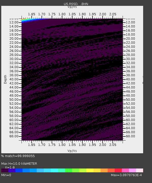
| Estimated Moho Depth: |
10.0 km |
| Estimated Crust Vp/Vs: |
1.60 |
| Assumed Crust Vp: |
6.242 km/s |
| Estimated Crust Vs: |
3.901 km/s |
| Estimated Crust Poisson's Ratio: |
0.18 |
|
| Radial Match: |
99.999855 % |
| Radial Bump: |
2 |
| Transverse Match: |
99.9949 % |
| Transverse Bump: |
2 |
| SOD ConfigId: |
110165 |
| Insert Time: |
2010-03-05 06:31:46.345 +0000 |
| GWidth: |
2.5 |
| Max Bumps: |
400 |
| Tol: |
0.001 |
|
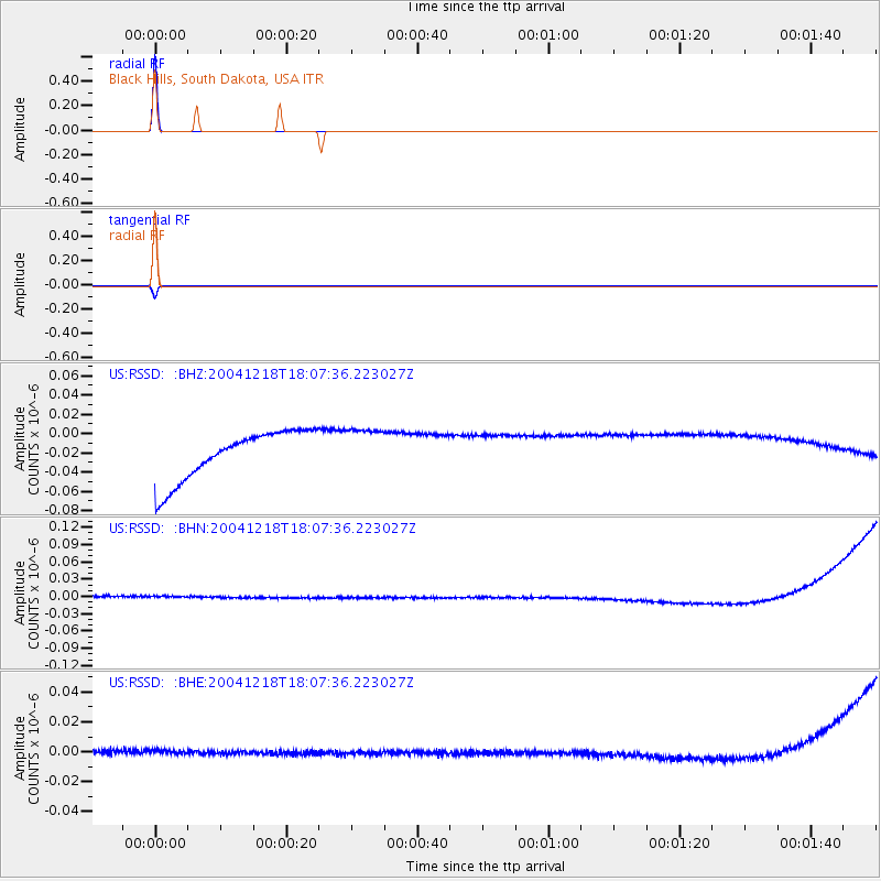
Signal To Noise
| Channel | StoN | STA | LTA |
| US:RSSD: :BHN:20041218T18:07:36.223027Z | 0.9341974 | 1.0095116E-8 | 1.0806191E-8 |
| US:RSSD: :BHE:20041218T18:07:36.223027Z | 0.9336306 | 4.1445745E-9 | 4.4392015E-9 |
| US:RSSD: :BHZ:20041218T18:07:36.223027Z | 0.9287603 | 2.3696824E-8 | 2.5514465E-8 |
| Arrivals |
| Ps | 1.0 SECOND |
| PpPs | 4.0 SECOND |
| PsPs/PpSs | 5.0 SECOND |


