You are here: Home > Network List > US - United States National Seismic Network Stations List
> Station RSSD Black Hills, South Dakota, USA > Earthquake Result Viewer
RSSD Black Hills, South Dakota, USA - Earthquake Result Viewer
| Earthquake location: |
Vanuatu Islands Region |
| Earthquake latitude/longitude: |
-13.4/172.4 |
| Earthquake time(UTC): |
2006/03/19 (078) 04:36:52 GMT |
| Earthquake Depth: |
10 km |
| Earthquake Magnitude: |
5.7 MB, 5.6 MS, 5.9 MW, 5.8 MW |
| Earthquake Catalog/Contributor: |
WHDF/NEIC |
|
| Network: |
US United States National Seismic Network |
| Station: |
RSSD Black Hills, South Dakota, USA |
| Lat/Lon: |
44.12 N/104.04 W |
| Elevation: |
2060 m |
|
| Distance: |
94.7 deg |
| Az: |
45.896 deg |
| Baz: |
255.964 deg |
| Ray Param: |
0.040983584 |
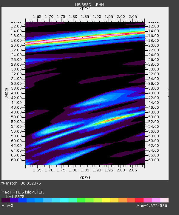
| Estimated Moho Depth: |
16.5 km |
| Estimated Crust Vp/Vs: |
1.84 |
| Assumed Crust Vp: |
6.242 km/s |
| Estimated Crust Vs: |
3.397 km/s |
| Estimated Crust Poisson's Ratio: |
0.29 |
|
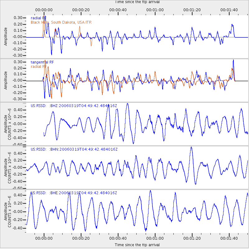
| Radial Match: |
80.032875 % |
| Radial Bump: |
366 |
| Transverse Match: |
61.742805 % |
| Transverse Bump: |
400 |
| SOD ConfigId: |
2669 |
| Insert Time: |
2010-03-05 06:32:11.197 +0000 |
| GWidth: |
2.5 |
| Max Bumps: |
400 |
| Tol: |
0.001 |
|
Signal To Noise
| Channel | StoN | STA | LTA |
| US:RSSD: :BHN:20060319T04:49:42.484016Z | 0.7603086 | 1.2092679E-7 | 1.590496E-7 |
| US:RSSD: :BHE:20060319T04:49:42.484016Z | 0.82873976 | 1.2533732E-7 | 1.5123847E-7 |
| US:RSSD: :BHZ:20060319T04:49:42.484016Z | 1.4854841 | 2.5998742E-7 | 1.7501864E-7 |
| Arrivals |
| Ps | 2.3 SECOND |
| PpPs | 7.4 SECOND |
| PsPs/PpSs | 9.6 SECOND |


