You are here: Home > Network List > US - United States National Seismic Network Stations List
> Station RSSD Black Hills, South Dakota, USA > Earthquake Result Viewer
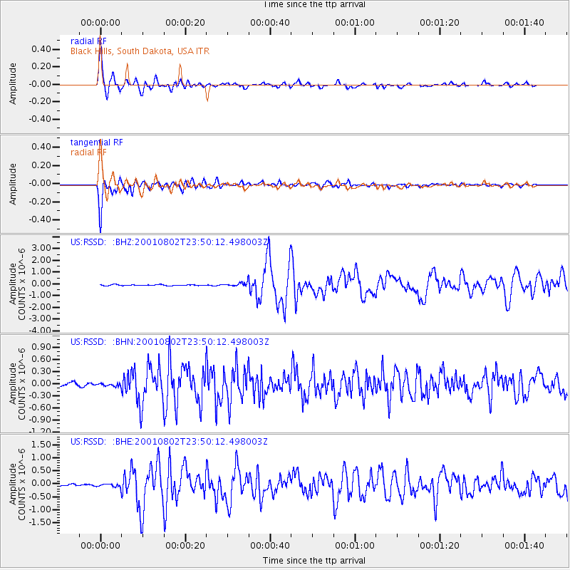
RSSD Black Hills, South Dakota, USA - Earthquake Result Viewer
| Earthquake location: |
Near East Coast Of Kamchatka |
| Earthquake latitude/longitude: |
56.3/163.8 |
| Earthquake time(UTC): |
2001/08/02 (214) 23:41:06 GMT |
| Earthquake Depth: |
14 km |
| Earthquake Magnitude: |
5.9 MB, 6.2 MS, 6.3 MW, 6.2 ME |
| Earthquake Catalog/Contributor: |
WHDF/NEIC |
|
| Network: |
US United States National Seismic Network |
| Station: |
RSSD Black Hills, South Dakota, USA |
| Lat/Lon: |
44.12 N/104.04 W |
| Elevation: |
2060 m |
|
| Distance: |
55.9 deg |
| Az: |
60.343 deg |
| Baz: |
317.679 deg |
| Ray Param: |
0.064474724 |
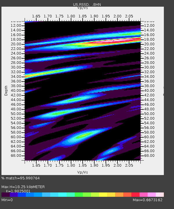
| Estimated Moho Depth: |
18.25 km |
| Estimated Crust Vp/Vs: |
1.98 |
| Assumed Crust Vp: |
6.242 km/s |
| Estimated Crust Vs: |
3.149 km/s |
| Estimated Crust Poisson's Ratio: |
0.33 |
|
| Radial Match: |
95.998764 % |
| Radial Bump: |
373 |
| Transverse Match: |
94.5468 % |
| Transverse Bump: |
400 |
| SOD ConfigId: |
110165 |
| Insert Time: |
2010-03-05 06:32:30.838 +0000 |
| GWidth: |
2.5 |
| Max Bumps: |
400 |
| Tol: |
0.001 |
|
Signal To Noise
| Channel | StoN | STA | LTA |
| US:RSSD: :BHN:20010802T23:50:12.498003Z | 0.8451389 | 3.1990858E-8 | 3.785278E-8 |
| US:RSSD: :BHE:20010802T23:50:12.498003Z | 2.3373375 | 6.889587E-8 | 2.9476219E-8 |
| US:RSSD: :BHZ:20010802T23:50:12.498003Z | 4.721439 | 1.8011318E-7 | 3.8147945E-8 |
| Arrivals |
| Ps | 3.0 SECOND |
| PpPs | 8.4 SECOND |
| PsPs/PpSs | 11 SECOND |


