You are here: Home > Network List > US - United States National Seismic Network Stations List
> Station RSSD Black Hills, South Dakota, USA > Earthquake Result Viewer
RSSD Black Hills, South Dakota, USA - Earthquake Result Viewer
| Earthquake location: |
Near Coast Of Peru |
| Earthquake latitude/longitude: |
-17.7/-71.6 |
| Earthquake time(UTC): |
2001/06/26 (177) 04:18:31 GMT |
| Earthquake Depth: |
24 km |
| Earthquake Magnitude: |
6.2 MB, 6.7 MS, 6.8 MW, 6.7 ME |
| Earthquake Catalog/Contributor: |
WHDF/NEIC |
|
| Network: |
US United States National Seismic Network |
| Station: |
RSSD Black Hills, South Dakota, USA |
| Lat/Lon: |
44.12 N/104.04 W |
| Elevation: |
2060 m |
|
| Distance: |
68.3 deg |
| Az: |
335.472 deg |
| Baz: |
146.679 deg |
| Ray Param: |
0.056352247 |
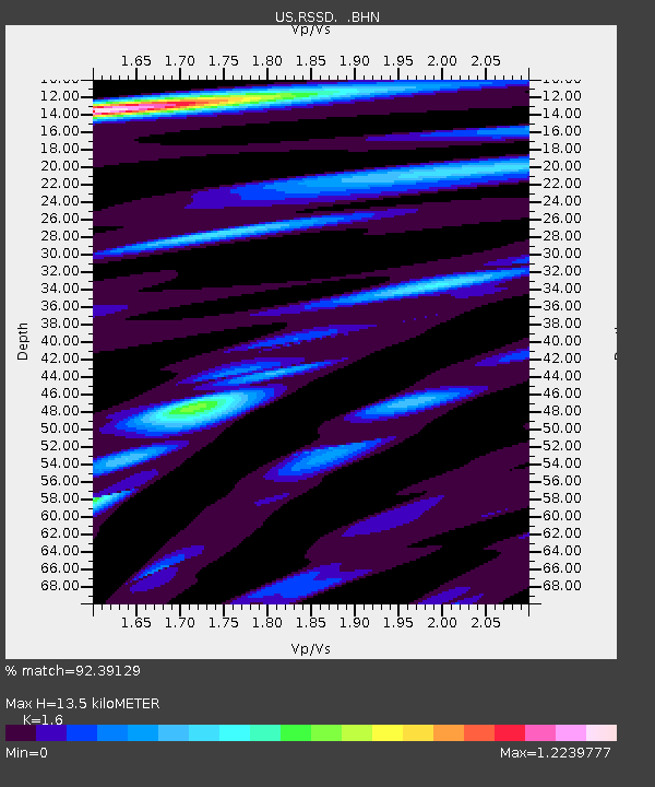
| Estimated Moho Depth: |
13.5 km |
| Estimated Crust Vp/Vs: |
1.60 |
| Assumed Crust Vp: |
6.242 km/s |
| Estimated Crust Vs: |
3.901 km/s |
| Estimated Crust Poisson's Ratio: |
0.18 |
|
| Radial Match: |
92.39129 % |
| Radial Bump: |
400 |
| Transverse Match: |
98.145706 % |
| Transverse Bump: |
383 |
| SOD ConfigId: |
110165 |
| Insert Time: |
2010-03-05 06:32:39.342 +0000 |
| GWidth: |
2.5 |
| Max Bumps: |
400 |
| Tol: |
0.001 |
|
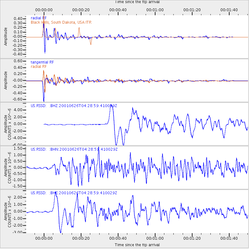
Signal To Noise
| Channel | StoN | STA | LTA |
| US:RSSD: :BHN:20010626T04:28:59.410029Z | 1.9156166 | 7.2196045E-8 | 3.768815E-8 |
| US:RSSD: :BHE:20010626T04:28:59.410029Z | 2.3865407 | 1.1350579E-7 | 4.7560803E-8 |
| US:RSSD: :BHZ:20010626T04:28:59.410029Z | 4.0583663 | 2.2991921E-7 | 5.6653143E-8 |
| Arrivals |
| Ps | 1.4 SECOND |
| PpPs | 5.4 SECOND |
| PsPs/PpSs | 6.8 SECOND |


