You are here: Home > Network List > XE05 - Sierra Nevada EarthScope Project- EarthScope Flex Array Stations List
> Station SNP84 SNP84 > Earthquake Result Viewer
SNP84 SNP84 - Earthquake Result Viewer
| Earthquake location: |
New Ireland Region, P.N.G. |
| Earthquake latitude/longitude: |
-4.5/153.5 |
| Earthquake time(UTC): |
2005/09/09 (252) 07:26:43 GMT |
| Earthquake Depth: |
90 km |
| Earthquake Magnitude: |
6.3 MB, 7.7 MW, 7.5 MW |
| Earthquake Catalog/Contributor: |
WHDF/NEIC |
|
| Network: |
XE Sierra Nevada EarthScope Project- EarthScope Flex Array |
| Station: |
SNP84 SNP84 |
| Lat/Lon: |
38.16 N/120.15 W |
| Elevation: |
1610 m |
|
| Distance: |
89.9 deg |
| Az: |
51.884 deg |
| Baz: |
264.22 deg |
| Ray Param: |
0.04169261 |
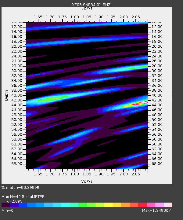
| Estimated Moho Depth: |
42.5 km |
| Estimated Crust Vp/Vs: |
2.10 |
| Assumed Crust Vp: |
6.597 km/s |
| Estimated Crust Vs: |
3.149 km/s |
| Estimated Crust Poisson's Ratio: |
0.35 |
|
| Radial Match: |
96.39999 % |
| Radial Bump: |
400 |
| Transverse Match: |
88.04812 % |
| Transverse Bump: |
400 |
| SOD ConfigId: |
268666 |
| Insert Time: |
2010-03-09 17:06:27.083 +0000 |
| GWidth: |
2.5 |
| Max Bumps: |
400 |
| Tol: |
0.001 |
|

Signal To Noise
| Channel | StoN | STA | LTA |
| XE:SNP84:01:BHZ:20050909T07:39:01.620015Z | 15.502145 | 1.0329468E-6 | 6.66325E-8 |
| XE:SNP84:01:BHN:20050909T07:39:01.620015Z | 1.0786476 | 7.544768E-8 | 6.994655E-8 |
| XE:SNP84:01:BHE:20050909T07:39:01.620015Z | 3.3983061 | 2.6531654E-7 | 7.807317E-8 |
| Arrivals |
| Ps | 7.2 SECOND |
| PpPs | 20 SECOND |
| PsPs/PpSs | 27 SECOND |


