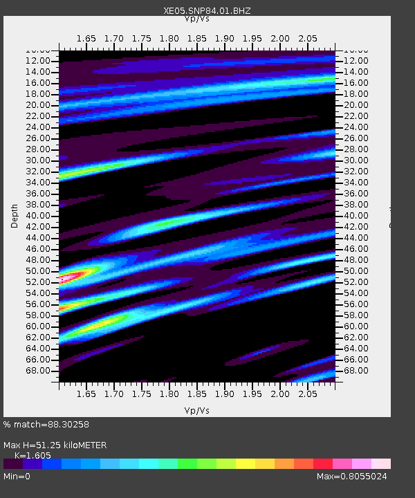
SNP84 SNP84 - Earthquake Result Viewer

Earthquake location: Kuril Islands
Earthquake latitude/longitude: 46.4/153.2
Earthquake time(UTC): 2006/09/30 (273) 17:50:23 GMT
Earthquake Depth: 11 km
Earthquake Magnitude: 6.1 MB, 6.5 MS, 6.6 MW, 6.6 MW
Earthquake Catalog/Contributor: WHDF/NEIC
Network: XE Sierra Nevada EarthScope Project- EarthScope Flex Array
Station: SNP84 SNP84
Lat/Lon: 38.16 N/120.15 W
Elevation: 1610 m
Distance: 61.6 deg
Az: 63.447 deg
Baz: 308.191 deg
Ray Param: 0.06075499
Estimated Moho Depth: 51.25 km
Estimated Crust Vp/Vs: 1.61
Assumed Crust Vp: 6.597 km/s
Estimated Crust Vs: 4.111 km/s
Estimated Crust Poisson's Ratio: 0.18
Radial Match: 88.30258 %
Radial Bump: 400
Transverse Match: 77.38097 %
Transverse Bump: 400
SOD ConfigId: 268666
Insert Time: 2010-03-09 17:07:11.888 +0000
GWidth: 2.5
Max Bumps: 400
Tol: 0.001

Signal To Noise

ChannelStoNSTALTA
XE:SNP84:01:BHZ:20060930T18:00:09.44502Z6.89015677.4351135E-71.0790921E-7
XE:SNP84:01:BHN:20060930T18:00:09.44502Z3.9207442.6998399E-76.88604E-8
XE:SNP84:01:BHE:20060930T18:00:09.44502Z1.73193132.3991973E-71.3852727E-7
Arrivals
Ps5.0 SECOND
PpPs19 SECOND
PsPs/PpSs24 SECOND