You are here: Home > Network List > XE05 - Sierra Nevada EarthScope Project- EarthScope Flex Array Stations List
> Station SNP84 SNP84 > Earthquake Result Viewer
SNP84 SNP84 - Earthquake Result Viewer
| Earthquake location: |
East Of Kuril Islands |
| Earthquake latitude/longitude: |
46.7/155.3 |
| Earthquake time(UTC): |
2006/11/15 (319) 11:34:58 GMT |
| Earthquake Depth: |
10 km |
| Earthquake Magnitude: |
6.4 MB |
| Earthquake Catalog/Contributor: |
WHDF/NEIC |
|
| Network: |
XE Sierra Nevada EarthScope Project- EarthScope Flex Array |
| Station: |
SNP84 SNP84 |
| Lat/Lon: |
38.16 N/120.15 W |
| Elevation: |
1610 m |
|
| Distance: |
60.2 deg |
| Az: |
64.786 deg |
| Baz: |
307.762 deg |
| Ray Param: |
0.06171559 |
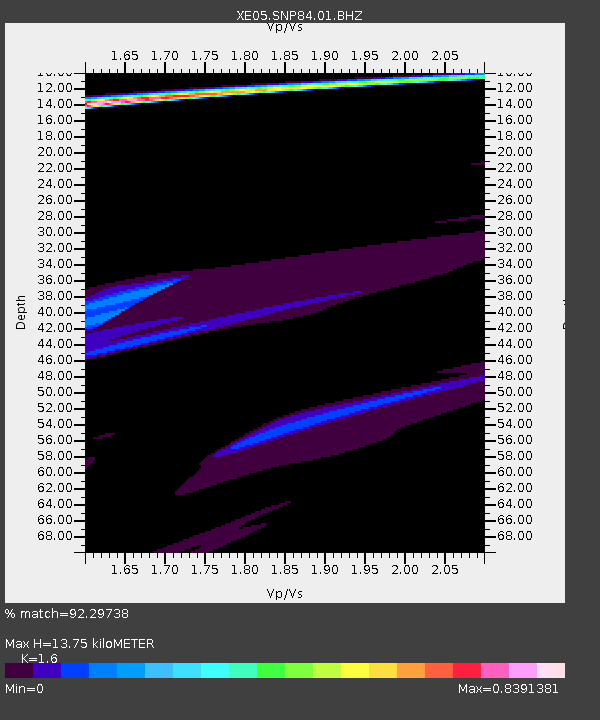
| Estimated Moho Depth: |
13.75 km |
| Estimated Crust Vp/Vs: |
1.60 |
| Assumed Crust Vp: |
6.597 km/s |
| Estimated Crust Vs: |
4.123 km/s |
| Estimated Crust Poisson's Ratio: |
0.18 |
|
| Radial Match: |
92.29738 % |
| Radial Bump: |
399 |
| Transverse Match: |
60.47582 % |
| Transverse Bump: |
400 |
| SOD ConfigId: |
268666 |
| Insert Time: |
2010-03-09 17:07:28.961 +0000 |
| GWidth: |
2.5 |
| Max Bumps: |
400 |
| Tol: |
0.001 |
|

Signal To Noise
| Channel | StoN | STA | LTA |
| XE:SNP84:01:BHZ:20061115T11:44:34.770015Z | 3.193013 | 1.21071396E-4 | 3.7917605E-5 |
| XE:SNP84:01:BHN:20061115T11:44:34.770015Z | 3.3519256 | 5.4017266E-5 | 1.6115293E-5 |
| XE:SNP84:01:BHE:20061115T11:44:34.770015Z | 1.1809317 | 3.8970178E-5 | 3.299952E-5 |
| Arrivals |
| Ps | 1.3 SECOND |
| PpPs | 5.1 SECOND |
| PsPs/PpSs | 6.4 SECOND |


