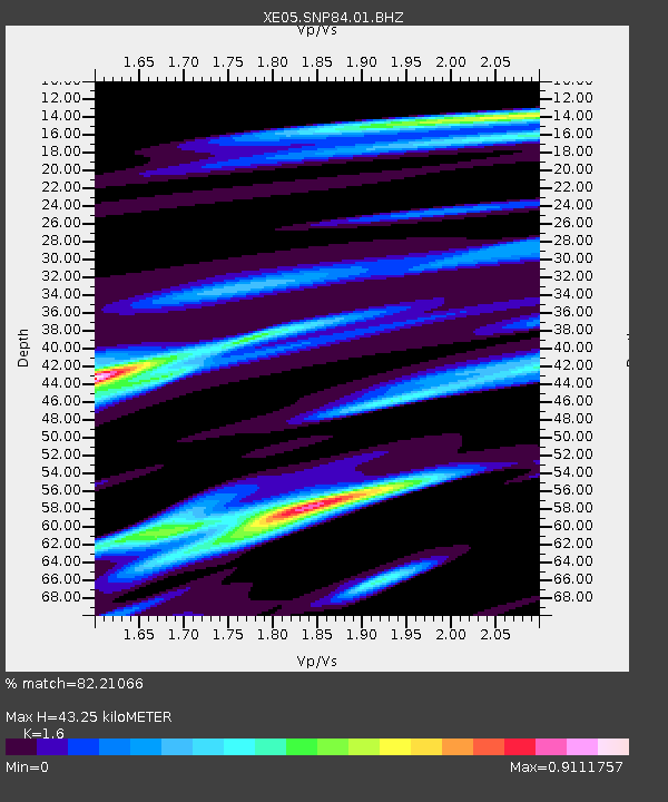
SNP84 SNP84 - Earthquake Result Viewer

Earthquake location: South Of Kermadec Islands
Earthquake latitude/longitude: -34.1/-178.9
Earthquake time(UTC): 2007/05/03 (123) 13:56:29 GMT
Earthquake Depth: 10 km
Earthquake Magnitude: 5.5 MB, 5.4 MS, 5.6 MW, 5.5 MW
Earthquake Catalog/Contributor: WHDF/NEIC
Network: XE Sierra Nevada EarthScope Project- EarthScope Flex Array
Station: SNP84 SNP84
Lat/Lon: 38.16 N/120.15 W
Elevation: 1610 m
Distance: 90.3 deg
Az: 42.403 deg
Baz: 225.209 deg
Ray Param: 0.041685525
Estimated Moho Depth: 43.25 km
Estimated Crust Vp/Vs: 1.60
Assumed Crust Vp: 6.597 km/s
Estimated Crust Vs: 4.123 km/s
Estimated Crust Poisson's Ratio: 0.18
Radial Match: 82.21066 %
Radial Bump: 400
Transverse Match: 70.80751 %
Transverse Bump: 400
SOD ConfigId: 268666
Insert Time: 2010-03-09 17:08:02.165 +0000
GWidth: 2.5
Max Bumps: 400
Tol: 0.001

Signal To Noise

ChannelStoNSTALTA
XE:SNP84:01:BHZ:20070503T14:08:59.01002Z1.44027724.470277E-73.1037615E-7
XE:SNP84:01:BHN:20070503T14:08:59.01002Z1.08415592.38721E-72.2019063E-7
XE:SNP84:01:BHE:20070503T14:08:59.01002Z1.88848963.738306E-71.9795216E-7
Arrivals
Ps4.0 SECOND
PpPs17 SECOND
PsPs/PpSs21 SECOND