You are here: Home > Network List > XG92 - Rocky Mountain Front Stations List
> Station KRM Kremlin, CO > Earthquake Result Viewer
KRM Kremlin, CO - Earthquake Result Viewer
| Earthquake location: |
Kyrgyzstan |
| Earthquake latitude/longitude: |
42.3/73.7 |
| Earthquake time(UTC): |
1992/08/19 (232) 02:12:58 GMT |
| Earthquake Depth: |
33 km |
| Earthquake Magnitude: |
6.1 MB |
| Earthquake Catalog/Contributor: |
WHDF/NEIC |
|
| Network: |
XG Rocky Mountain Front |
| Station: |
KRM Kremlin, CO |
| Lat/Lon: |
40.13 N/106.40 W |
| Elevation: |
2458 m |
|
| Distance: |
97.9 deg |
| Az: |
0.058 deg |
| Baz: |
359.944 deg |
| Ray Param: |
0.040044937 |
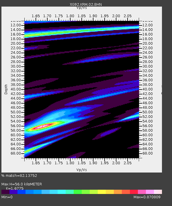
| Estimated Moho Depth: |
56.0 km |
| Estimated Crust Vp/Vs: |
1.68 |
| Assumed Crust Vp: |
6.159 km/s |
| Estimated Crust Vs: |
3.671 km/s |
| Estimated Crust Poisson's Ratio: |
0.22 |
|
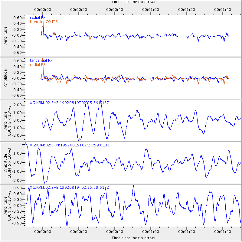
| Radial Match: |
82.13752 % |
| Radial Bump: |
364 |
| Transverse Match: |
54.489094 % |
| Transverse Bump: |
400 |
| SOD ConfigId: |
3286 |
| Insert Time: |
2010-02-25 20:09:33.954 +0000 |
| GWidth: |
2.5 |
| Max Bumps: |
400 |
| Tol: |
0.001 |
|
Signal To Noise
| Channel | StoN | STA | LTA |
| XG:KRM:02:BHN:19920819T02:25:59.613Z | 1.5541799 | 0.0014619135 | 9.4063336E-4 |
| XG:KRM:02:BHE:19920819T02:25:59.613Z | 0.9689879 | 4.178555E-4 | 4.312288E-4 |
| XG:KRM:02:BHZ:19920819T02:25:59.613Z | 1.3973743 | 0.0015913203 | 0.0011387931 |
| Arrivals |
| Ps | 6.3 SECOND |
| PpPs | 24 SECOND |
| PsPs/PpSs | 30 SECOND |


