You are here: Home > Network List > XG92 - Rocky Mountain Front Stations List
> Station KRM Kremlin, CO > Earthquake Result Viewer
KRM Kremlin, CO - Earthquake Result Viewer
| Earthquake location: |
Colombia |
| Earthquake latitude/longitude: |
5.1/-75.7 |
| Earthquake time(UTC): |
1992/08/15 (228) 19:02:09 GMT |
| Earthquake Depth: |
127 km |
| Earthquake Magnitude: |
5.7 MB |
| Earthquake Catalog/Contributor: |
WHDF/NEIC |
|
| Network: |
XG Rocky Mountain Front |
| Station: |
KRM Kremlin, CO |
| Lat/Lon: |
40.13 N/106.40 W |
| Elevation: |
2458 m |
|
| Distance: |
44.5 deg |
| Az: |
326.073 deg |
| Baz: |
133.52 deg |
| Ray Param: |
0.07143216 |
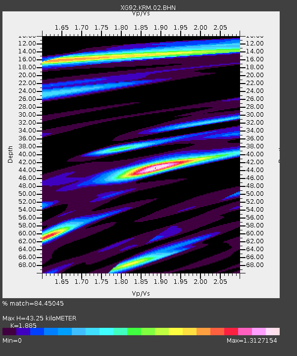
| Estimated Moho Depth: |
43.25 km |
| Estimated Crust Vp/Vs: |
1.88 |
| Assumed Crust Vp: |
6.159 km/s |
| Estimated Crust Vs: |
3.267 km/s |
| Estimated Crust Poisson's Ratio: |
0.30 |
|
| Radial Match: |
84.45045 % |
| Radial Bump: |
400 |
| Transverse Match: |
67.86222 % |
| Transverse Bump: |
400 |
| SOD ConfigId: |
3286 |
| Insert Time: |
2010-02-25 20:09:36.550 +0000 |
| GWidth: |
2.5 |
| Max Bumps: |
400 |
| Tol: |
0.001 |
|
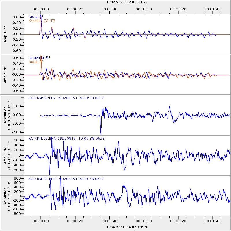
Signal To Noise
| Channel | StoN | STA | LTA |
| XG:KRM:02:BHN:19920815T19:09:38.063Z | 1.0730067 | 7.5104035E-5 | 6.9994E-5 |
| XG:KRM:02:BHE:19920815T19:09:38.063Z | 0.9211829 | 6.816095E-5 | 7.399286E-5 |
| XG:KRM:02:BHZ:19920815T19:09:38.063Z | 3.7959185 | 1.7067528E-4 | 4.4962842E-5 |
| Arrivals |
| Ps | 6.6 SECOND |
| PpPs | 19 SECOND |
| PsPs/PpSs | 26 SECOND |


