You are here: Home > Network List > 4A - Mapping the structure of the Duluth Complex & Animikie Basin (DABS) Stations List
> Station MN03 MN03 > Earthquake Result Viewer
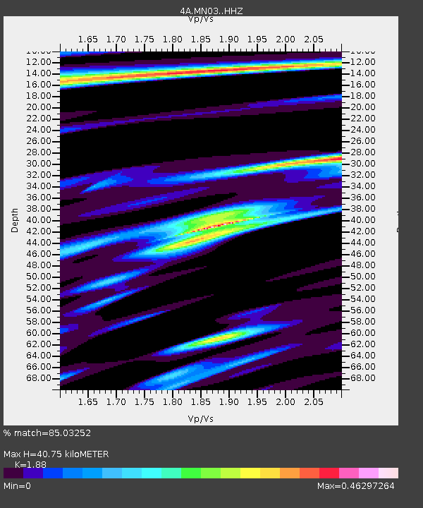
MN03 MN03 - Earthquake Result Viewer
| Earthquake location: |
Near West Coast Of Honshu, Japan |
| Earthquake latitude/longitude: |
37.5/137.3 |
| Earthquake time(UTC): |
2023/05/05 (125) 05:42:04 GMT |
| Earthquake Depth: |
8.7 km |
| Earthquake Magnitude: |
6.2 mww |
| Earthquake Catalog/Contributor: |
NEIC PDE/us |
|
| Network: |
4A Mapping the structure of the Duluth Complex & Animikie Basin (DABS) |
| Station: |
MN03 MN03 |
| Lat/Lon: |
46.99 N/92.24 W |
| Elevation: |
412 m |
|
| Distance: |
84.9 deg |
| Az: |
31.531 deg |
| Baz: |
322.607 deg |
| Ray Param: |
0.045173302 |
| Estimated Moho Depth: |
40.75 km |
| Estimated Crust Vp/Vs: |
1.88 |
| Assumed Crust Vp: |
6.571 km/s |
| Estimated Crust Vs: |
3.495 km/s |
| Estimated Crust Poisson's Ratio: |
0.30 |
|
| Radial Match: |
85.03252 % |
| Radial Bump: |
328 |
| Transverse Match: |
69.35657 % |
| Transverse Bump: |
400 |
| SOD ConfigId: |
34243671 |
| Insert Time: |
2024-05-04 01:36:06.673 +0000 |
| GWidth: |
2.5 |
| Max Bumps: |
400 |
| Tol: |
0.001 |
|

Signal To Noise
| Channel | StoN | STA | LTA |
| 4A:MN03: :HHZ:20230505T05:54:07.739998Z | 12.680194 | 2.055208E-6 | 1.6208016E-7 |
| 4A:MN03: :HH1:20230505T05:54:07.739998Z | 4.3701696 | 6.530894E-7 | 1.4944258E-7 |
| 4A:MN03: :HH2:20230505T05:54:07.739998Z | 3.5712657 | 4.8513334E-7 | 1.3584354E-7 |
| Arrivals |
| Ps | 5.6 SECOND |
| PpPs | 17 SECOND |
| PsPs/PpSs | 23 SECOND |


