You are here: Home > Network List > 4A - Mapping the structure of the Duluth Complex & Animikie Basin (DABS) Stations List
> Station MN03 MN03 > Earthquake Result Viewer
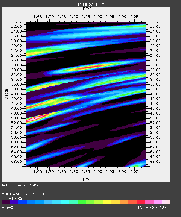
MN03 MN03 - Earthquake Result Viewer
| Earthquake location: |
Alaska Peninsula |
| Earthquake latitude/longitude: |
54.5/-160.8 |
| Earthquake time(UTC): |
2023/07/16 (197) 06:48:21 GMT |
| Earthquake Depth: |
21 km |
| Earthquake Magnitude: |
7.3 Mi |
| Earthquake Catalog/Contributor: |
NEIC PDE/at |
|
| Network: |
4A Mapping the structure of the Duluth Complex & Animikie Basin (DABS) |
| Station: |
MN03 MN03 |
| Lat/Lon: |
46.99 N/92.24 W |
| Elevation: |
412 m |
|
| Distance: |
42.4 deg |
| Az: |
70.786 deg |
| Baz: |
306.407 deg |
| Ray Param: |
0.07315649 |
| Estimated Moho Depth: |
50.0 km |
| Estimated Crust Vp/Vs: |
1.63 |
| Assumed Crust Vp: |
6.571 km/s |
| Estimated Crust Vs: |
4.019 km/s |
| Estimated Crust Poisson's Ratio: |
0.20 |
|
| Radial Match: |
94.95667 % |
| Radial Bump: |
400 |
| Transverse Match: |
76.33936 % |
| Transverse Bump: |
400 |
| SOD ConfigId: |
34243671 |
| Insert Time: |
2024-05-05 03:04:09.848 +0000 |
| GWidth: |
2.5 |
| Max Bumps: |
400 |
| Tol: |
0.001 |
|

Signal To Noise
| Channel | StoN | STA | LTA |
| 4A:MN03: :HHZ:20230716T06:55:43.160004Z | 61.043613 | 3.7057002E-6 | 6.070578E-8 |
| 4A:MN03: :HH1:20230716T06:55:43.160004Z | 26.666323 | 1.3720968E-6 | 5.1454293E-8 |
| 4A:MN03: :HH2:20230716T06:55:43.160004Z | 34.60344 | 1.7825548E-6 | 5.1513805E-8 |
| Arrivals |
| Ps | 5.2 SECOND |
| PpPs | 19 SECOND |
| PsPs/PpSs | 24 SECOND |


