You are here: Home > Network List > 4A - Mapping the structure of the Duluth Complex & Animikie Basin (DABS) Stations List
> Station MN03 MN03 > Earthquake Result Viewer
MN03 MN03 - Earthquake Result Viewer
| Earthquake location: |
Off Coast Of Central America |
| Earthquake latitude/longitude: |
12.8/-88.1 |
| Earthquake time(UTC): |
2023/07/19 (200) 00:22:07 GMT |
| Earthquake Depth: |
70 km |
| Earthquake Magnitude: |
6.5 mww |
| Earthquake Catalog/Contributor: |
NEIC PDE/us |
|
| Network: |
4A Mapping the structure of the Duluth Complex & Animikie Basin (DABS) |
| Station: |
MN03 MN03 |
| Lat/Lon: |
46.99 N/92.24 W |
| Elevation: |
412 m |
|
| Distance: |
34.2 deg |
| Az: |
354.994 deg |
| Baz: |
172.858 deg |
| Ray Param: |
0.07765214 |
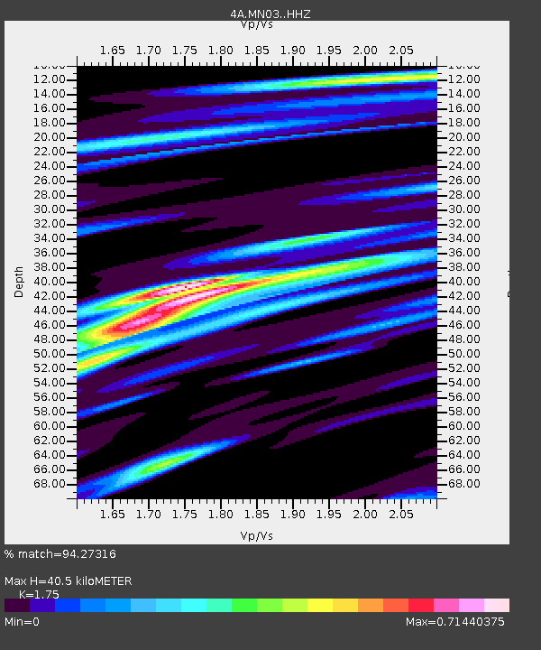
| Estimated Moho Depth: |
40.5 km |
| Estimated Crust Vp/Vs: |
1.75 |
| Assumed Crust Vp: |
6.571 km/s |
| Estimated Crust Vs: |
3.755 km/s |
| Estimated Crust Poisson's Ratio: |
0.26 |
|
| Radial Match: |
94.27316 % |
| Radial Bump: |
237 |
| Transverse Match: |
70.6486 % |
| Transverse Bump: |
400 |
| SOD ConfigId: |
34243671 |
| Insert Time: |
2024-05-05 04:04:30.347 +0000 |
| GWidth: |
2.5 |
| Max Bumps: |
400 |
| Tol: |
0.001 |
|

Signal To Noise
| Channel | StoN | STA | LTA |
| 4A:MN03: :HHZ:20230719T00:28:16.619986Z | 19.834055 | 1.2499837E-6 | 6.30221E-8 |
| 4A:MN03: :HH1:20230719T00:28:16.619986Z | 18.979824 | 9.847749E-7 | 5.1885355E-8 |
| 4A:MN03: :HH2:20230719T00:28:16.619986Z | 5.357603 | 2.4311942E-7 | 4.5378396E-8 |
| Arrivals |
| Ps | 5.0 SECOND |
| PpPs | 16 SECOND |
| PsPs/PpSs | 21 SECOND |


