You are here: Home > Network List > 4A - Mapping the structure of the Duluth Complex & Animikie Basin (DABS) Stations List
> Station MN03 MN03 > Earthquake Result Viewer
MN03 MN03 - Earthquake Result Viewer
| Earthquake location: |
South Of Panama |
| Earthquake latitude/longitude: |
5.6/-82.6 |
| Earthquake time(UTC): |
2023/08/03 (215) 01:25:21 GMT |
| Earthquake Depth: |
8.0 km |
| Earthquake Magnitude: |
5.9 mww |
| Earthquake Catalog/Contributor: |
NEIC PDE/us |
|
| Network: |
4A Mapping the structure of the Duluth Complex & Animikie Basin (DABS) |
| Station: |
MN03 MN03 |
| Lat/Lon: |
46.99 N/92.24 W |
| Elevation: |
412 m |
|
| Distance: |
42.0 deg |
| Az: |
350.164 deg |
| Baz: |
165.619 deg |
| Ray Param: |
0.07342185 |
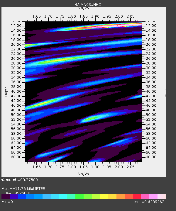
| Estimated Moho Depth: |
11.75 km |
| Estimated Crust Vp/Vs: |
1.99 |
| Assumed Crust Vp: |
6.571 km/s |
| Estimated Crust Vs: |
3.298 km/s |
| Estimated Crust Poisson's Ratio: |
0.33 |
|
| Radial Match: |
93.77589 % |
| Radial Bump: |
334 |
| Transverse Match: |
65.30966 % |
| Transverse Bump: |
400 |
| SOD ConfigId: |
34243671 |
| Insert Time: |
2024-05-05 07:06:34.941 +0000 |
| GWidth: |
2.5 |
| Max Bumps: |
400 |
| Tol: |
0.001 |
|

Signal To Noise
| Channel | StoN | STA | LTA |
| 4A:MN03: :HHZ:20230803T01:32:42.559988Z | 16.917805 | 1.3302584E-6 | 7.863068E-8 |
| 4A:MN03: :HH1:20230803T01:32:42.559988Z | 8.425789 | 8.354179E-7 | 9.915011E-8 |
| 4A:MN03: :HH2:20230803T01:32:42.559988Z | 1.6502666 | 2.3438405E-7 | 1.4202799E-7 |
| Arrivals |
| Ps | 1.9 SECOND |
| PpPs | 5.0 SECOND |
| PsPs/PpSs | 6.9 SECOND |


