You are here: Home > Network List > AB - National Seismic Network of Azerbaijan () Stations List
> Station TELL Tel, Azerbaijan > Earthquake Result Viewer
TELL Tel, Azerbaijan - Earthquake Result Viewer
| Earthquake location: |
Banda Sea |
| Earthquake latitude/longitude: |
-6.5/129.8 |
| Earthquake time(UTC): |
2023/11/08 (312) 04:52:52 GMT |
| Earthquake Depth: |
10 km |
| Earthquake Magnitude: |
6.9 Mi |
| Earthquake Catalog/Contributor: |
NEIC PDE/pt |
|
| Network: |
AB National Seismic Network of Azerbaijan () |
| Station: |
TELL Tel, Azerbaijan |
| Lat/Lon: |
41.76 N/48.64 E |
| Elevation: |
27 m |
|
| Distance: |
87.7 deg |
| Az: |
312.287 deg |
| Baz: |
100.707 deg |
| Ray Param: |
0.043146316 |
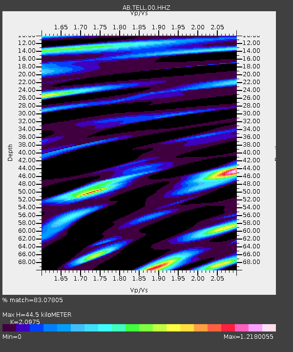
| Estimated Moho Depth: |
44.5 km |
| Estimated Crust Vp/Vs: |
2.10 |
| Assumed Crust Vp: |
6.008 km/s |
| Estimated Crust Vs: |
2.864 km/s |
| Estimated Crust Poisson's Ratio: |
0.35 |
|
| Radial Match: |
83.07805 % |
| Radial Bump: |
400 |
| Transverse Match: |
77.45949 % |
| Transverse Bump: |
400 |
| SOD ConfigId: |
34243671 |
| Insert Time: |
2024-05-06 18:26:58.774 +0000 |
| GWidth: |
2.5 |
| Max Bumps: |
400 |
| Tol: |
0.001 |
|

Signal To Noise
| Channel | StoN | STA | LTA |
| AB:TELL:00:HHZ:20231108T05:05:08.380005Z | 2.6777496 | 9.393166E-7 | 3.507858E-7 |
| AB:TELL:00:HHN:20231108T05:05:08.380005Z | 1.0306139 | 3.7035298E-7 | 3.5935184E-7 |
| AB:TELL:00:HHE:20231108T05:05:08.380005Z | 1.0058211 | 2.8241968E-7 | 2.807852E-7 |
| Arrivals |
| Ps | 8.3 SECOND |
| PpPs | 23 SECOND |
| PsPs/PpSs | 31 SECOND |


