You are here: Home > Network List > YB13 - Continental Dynamics/Cent. Anatolian Tectonics:Surface to Mantle Dynamics During Stations List
> Station AT02 Karatas,Sivas,Turkey > Earthquake Result Viewer
AT02 Karatas,Sivas,Turkey - Earthquake Result Viewer
| Earthquake location: |
North Atlantic Ocean |
| Earthquake latitude/longitude: |
14.7/-58.9 |
| Earthquake time(UTC): |
2014/02/18 (049) 09:27:13 GMT |
| Earthquake Depth: |
17 km |
| Earthquake Magnitude: |
6.5 MWW, 6.3 MWB, 6.5 MWC, 6.6 MWC, 6.7 MI |
| Earthquake Catalog/Contributor: |
NEIC PDE/NEIC COMCAT |
|
| Network: |
YB Continental Dynamics/Cent. Anatolian Tectonics:Surface to Mantle Dynamics During |
| Station: |
AT02 Karatas,Sivas,Turkey |
| Lat/Lon: |
39.38 N/37.06 E |
| Elevation: |
1532 m |
|
| Distance: |
85.4 deg |
| Az: |
50.653 deg |
| Baz: |
285.036 deg |
| Ray Param: |
0.044795793 |
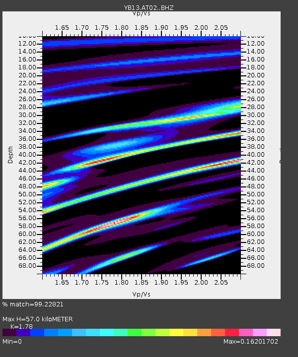
| Estimated Moho Depth: |
57.0 km |
| Estimated Crust Vp/Vs: |
1.78 |
| Assumed Crust Vp: |
6.35 km/s |
| Estimated Crust Vs: |
3.567 km/s |
| Estimated Crust Poisson's Ratio: |
0.27 |
|
| Radial Match: |
99.22821 % |
| Radial Bump: |
82 |
| Transverse Match: |
83.08409 % |
| Transverse Bump: |
400 |
| SOD ConfigId: |
3390531 |
| Insert Time: |
2019-04-10 09:15:46.487 +0000 |
| GWidth: |
2.5 |
| Max Bumps: |
400 |
| Tol: |
0.001 |
|

Signal To Noise
| Channel | StoN | STA | LTA |
| YB:AT02: :BHZ:20140218T09:39:18.440027Z | 21.381039 | 1.1715168E-6 | 5.4792324E-8 |
| YB:AT02: :BHN:20140218T09:39:18.440027Z | 1.145847 | 9.5716445E-8 | 8.353336E-8 |
| YB:AT02: :BHE:20140218T09:39:18.440027Z | 21.43416 | 8.257625E-7 | 3.852554E-8 |
| Arrivals |
| Ps | 7.2 SECOND |
| PpPs | 24 SECOND |
| PsPs/PpSs | 32 SECOND |


