You are here: Home > Network List > YB13 - Continental Dynamics/Cent. Anatolian Tectonics:Surface to Mantle Dynamics During Stations List
> Station AT02 Karatas,Sivas,Turkey > Earthquake Result Viewer
AT02 Karatas,Sivas,Turkey - Earthquake Result Viewer
| Earthquake location: |
Ryukyu Islands, Japan |
| Earthquake latitude/longitude: |
27.4/127.4 |
| Earthquake time(UTC): |
2014/03/02 (061) 20:11:23 GMT |
| Earthquake Depth: |
119 km |
| Earthquake Magnitude: |
6.5 MWW, 6.4 MWB, 6.5 MWC, 6.6 MI, 6.7 MI |
| Earthquake Catalog/Contributor: |
NEIC PDE/NEIC COMCAT |
|
| Network: |
YB Continental Dynamics/Cent. Anatolian Tectonics:Surface to Mantle Dynamics During |
| Station: |
AT02 Karatas,Sivas,Turkey |
| Lat/Lon: |
39.38 N/37.06 E |
| Elevation: |
1532 m |
|
| Distance: |
73.4 deg |
| Az: |
306.024 deg |
| Baz: |
68.05 deg |
| Ray Param: |
0.05274036 |
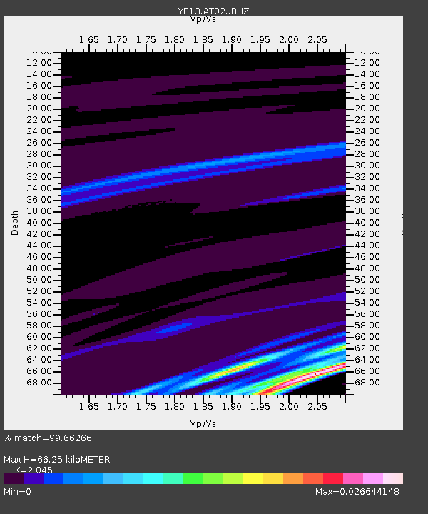
| Estimated Moho Depth: |
66.25 km |
| Estimated Crust Vp/Vs: |
2.05 |
| Assumed Crust Vp: |
6.35 km/s |
| Estimated Crust Vs: |
3.105 km/s |
| Estimated Crust Poisson's Ratio: |
0.34 |
|
| Radial Match: |
99.66266 % |
| Radial Bump: |
45 |
| Transverse Match: |
99.96529 % |
| Transverse Bump: |
4 |
| SOD ConfigId: |
3390531 |
| Insert Time: |
2019-04-10 12:05:11.483 +0000 |
| GWidth: |
2.5 |
| Max Bumps: |
400 |
| Tol: |
0.001 |
|

Signal To Noise
| Channel | StoN | STA | LTA |
| YB:AT02: :BHZ:20140302T20:22:10.70002Z | 24.980282 | 1.624523E-6 | 6.503221E-8 |
| YB:AT02: :BHN:20140302T20:22:10.70002Z | 25.039589 | 1.9670408E-6 | 7.855723E-8 |
| YB:AT02: :BHE:20140302T20:22:10.70002Z | 1.0660917 | 2.31086E-8 | 2.1675998E-8 |
| Arrivals |
| Ps | 11 SECOND |
| PpPs | 31 SECOND |
| PsPs/PpSs | 42 SECOND |


