You are here: Home > Network List > YB13 - Continental Dynamics/Cent. Anatolian Tectonics:Surface to Mantle Dynamics During Stations List
> Station AT02 Karatas,Sivas,Turkey > Earthquake Result Viewer
AT02 Karatas,Sivas,Turkey - Earthquake Result Viewer
| Earthquake location: |
Southeast Of Honshu, Japan |
| Earthquake latitude/longitude: |
29.3/139.4 |
| Earthquake time(UTC): |
2014/03/22 (081) 14:18:47 GMT |
| Earthquake Depth: |
425 km |
| Earthquake Magnitude: |
5.4 mb |
| Earthquake Catalog/Contributor: |
ISC/ISC |
|
| Network: |
YB Continental Dynamics/Cent. Anatolian Tectonics:Surface to Mantle Dynamics During |
| Station: |
AT02 Karatas,Sivas,Turkey |
| Lat/Lon: |
39.38 N/37.06 E |
| Elevation: |
1532 m |
|
| Distance: |
80.6 deg |
| Az: |
309.871 deg |
| Baz: |
59.855 deg |
| Ray Param: |
0.046974786 |
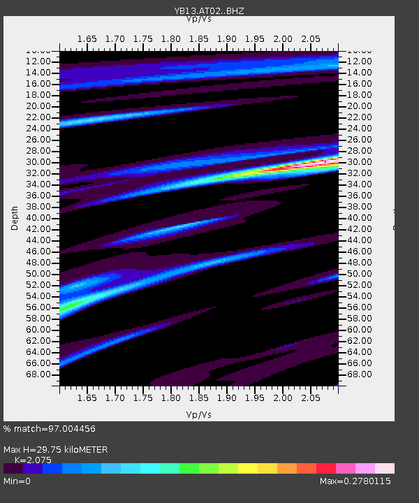
| Estimated Moho Depth: |
29.75 km |
| Estimated Crust Vp/Vs: |
2.08 |
| Assumed Crust Vp: |
6.35 km/s |
| Estimated Crust Vs: |
3.06 km/s |
| Estimated Crust Poisson's Ratio: |
0.35 |
|
| Radial Match: |
97.004456 % |
| Radial Bump: |
241 |
| Transverse Match: |
99.738914 % |
| Transverse Bump: |
25 |
| SOD ConfigId: |
3390531 |
| Insert Time: |
2019-04-10 20:16:23.135 +0000 |
| GWidth: |
2.5 |
| Max Bumps: |
400 |
| Tol: |
0.001 |
|

Signal To Noise
| Channel | StoN | STA | LTA |
| YB:AT02: :BHZ:20140322T14:29:43.320Z | 2.4987764 | 2.8076664E-7 | 1.1236165E-7 |
| YB:AT02: :BHN:20140322T14:29:43.320Z | 2.5841684 | 3.3081346E-7 | 1.2801544E-7 |
| YB:AT02: :BHE:20140322T14:29:43.320Z | 0.9598024 | 1.9693434E-8 | 2.0518218E-8 |
| Arrivals |
| Ps | 5.1 SECOND |
| PpPs | 14 SECOND |
| PsPs/PpSs | 19 SECOND |


