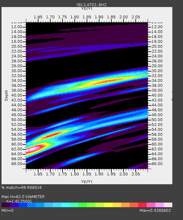
AT02 Karatas,Sivas,Turkey - Earthquake Result Viewer

Earthquake location: Southeast Of Ryukyu Islands
Earthquake latitude/longitude: 28.2/131.5
Earthquake time(UTC): 2014/03/26 (085) 08:49:41 GMT
Earthquake Depth: 10 km
Earthquake Magnitude: 5.6 MWP, 1.0 MI, 5.4 MWC, 5.5 MWW
Earthquake Catalog/Contributor: NEIC PDE/NEIC COMCAT
Network: YB Continental Dynamics/Cent. Anatolian Tectonics:Surface to Mantle Dynamics During
Station: AT02 Karatas,Sivas,Turkey
Lat/Lon: 39.38 N/37.06 E
Elevation: 1532 m
Distance: 75.9 deg
Az: 307.172 deg
Baz: 65.192 deg
Ray Param: 0.051374897
Estimated Moho Depth: 62.0 km
Estimated Crust Vp/Vs: 1.61
Assumed Crust Vp: 6.35 km/s
Estimated Crust Vs: 3.938 km/s
Estimated Crust Poisson's Ratio: 0.19
Radial Match: 89.986534 %
Radial Bump: 400
Transverse Match: 99.066864 %
Transverse Bump: 88
SOD ConfigId: 3390531
Insert Time: 2019-04-10 22:00:22.473 +0000
GWidth: 2.5
Max Bumps: 400
Tol: 0.001

Signal To Noise

ChannelStoNSTALTA
YB:AT02: :BHZ:20140326T09:00:57.400024Z2.75491521.5388592E-75.5858674E-8
YB:AT02: :BHN:20140326T09:00:57.400024Z2.67272621.7965591E-76.721823E-8
YB:AT02: :BHE:20140326T09:00:57.400024Z0.878981651.7334763E-81.9721416E-8
Arrivals
Ps6.2 SECOND
PpPs25 SECOND
PsPs/PpSs31 SECOND