You are here: Home > Network List > YB13 - Continental Dynamics/Cent. Anatolian Tectonics:Surface to Mantle Dynamics During Stations List
> Station AT02 Karatas,Sivas,Turkey > Earthquake Result Viewer
AT02 Karatas,Sivas,Turkey - Earthquake Result Viewer
| Earthquake location: |
Off East Coast Of Honshu, Japan |
| Earthquake latitude/longitude: |
37.9/144.2 |
| Earthquake time(UTC): |
2014/05/02 (122) 09:15:20 GMT |
| Earthquake Depth: |
15 km |
| Earthquake Magnitude: |
5.9 MWP |
| Earthquake Catalog/Contributor: |
NEIC PDE/NEIC COMCAT |
|
| Network: |
YB Continental Dynamics/Cent. Anatolian Tectonics:Surface to Mantle Dynamics During |
| Station: |
AT02 Karatas,Sivas,Turkey |
| Lat/Lon: |
39.38 N/37.06 E |
| Elevation: |
1532 m |
|
| Distance: |
78.2 deg |
| Az: |
310.843 deg |
| Baz: |
50.568 deg |
| Ray Param: |
0.049820744 |
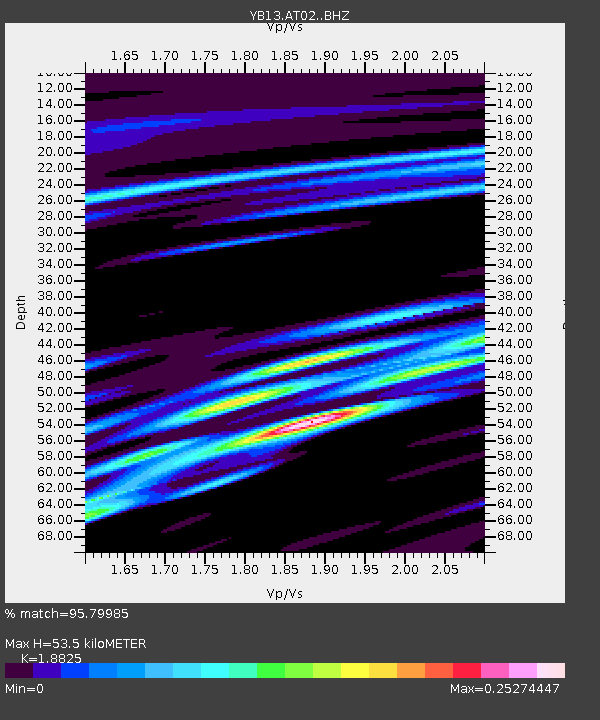
| Estimated Moho Depth: |
53.5 km |
| Estimated Crust Vp/Vs: |
1.88 |
| Assumed Crust Vp: |
6.35 km/s |
| Estimated Crust Vs: |
3.373 km/s |
| Estimated Crust Poisson's Ratio: |
0.30 |
|
| Radial Match: |
95.79985 % |
| Radial Bump: |
155 |
| Transverse Match: |
99.68412 % |
| Transverse Bump: |
53 |
| SOD ConfigId: |
3390531 |
| Insert Time: |
2019-04-11 16:30:31.408 +0000 |
| GWidth: |
2.5 |
| Max Bumps: |
400 |
| Tol: |
0.001 |
|

Signal To Noise
| Channel | StoN | STA | LTA |
| YB:AT02: :BHZ:20140502T09:26:47.859978Z | 4.177407 | 2.228643E-7 | 5.3349915E-8 |
| YB:AT02: :BHN:20140502T09:26:47.859978Z | 3.8266873 | 2.6915316E-7 | 7.033581E-8 |
| YB:AT02: :BHE:20140502T09:26:47.859978Z | 0.84431577 | 1.8866153E-8 | 2.2344901E-8 |
| Arrivals |
| Ps | 7.6 SECOND |
| PpPs | 24 SECOND |
| PsPs/PpSs | 31 SECOND |


