You are here: Home > Network List > YB13 - Continental Dynamics/Cent. Anatolian Tectonics:Surface to Mantle Dynamics During Stations List
> Station AT02 Karatas,Sivas,Turkey > Earthquake Result Viewer
AT02 Karatas,Sivas,Turkey - Earthquake Result Viewer
| Earthquake location: |
Bay Of Bengal |
| Earthquake latitude/longitude: |
18.3/88.1 |
| Earthquake time(UTC): |
2014/05/21 (141) 16:21:54 GMT |
| Earthquake Depth: |
40 km |
| Earthquake Magnitude: |
6.0 MWB |
| Earthquake Catalog/Contributor: |
NEIC PDE/NEIC COMCAT |
|
| Network: |
YB Continental Dynamics/Cent. Anatolian Tectonics:Surface to Mantle Dynamics During |
| Station: |
AT02 Karatas,Sivas,Turkey |
| Lat/Lon: |
39.38 N/37.06 E |
| Elevation: |
1532 m |
|
| Distance: |
48.7 deg |
| Az: |
306.678 deg |
| Baz: |
100.463 deg |
| Ray Param: |
0.069095284 |
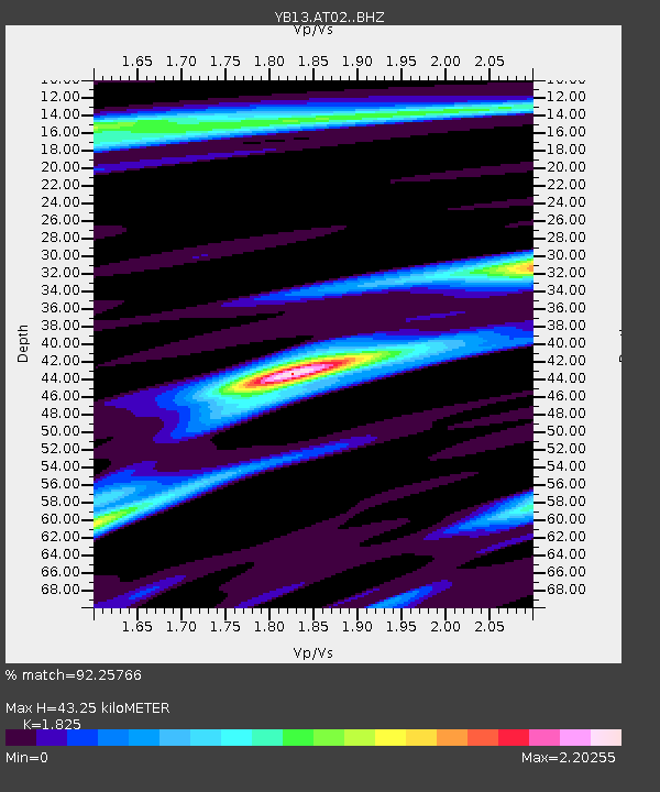
| Estimated Moho Depth: |
43.25 km |
| Estimated Crust Vp/Vs: |
1.83 |
| Assumed Crust Vp: |
6.35 km/s |
| Estimated Crust Vs: |
3.479 km/s |
| Estimated Crust Poisson's Ratio: |
0.29 |
|
| Radial Match: |
92.25766 % |
| Radial Bump: |
400 |
| Transverse Match: |
93.67424 % |
| Transverse Bump: |
400 |
| SOD ConfigId: |
3390531 |
| Insert Time: |
2019-04-11 23:56:12.918 +0000 |
| GWidth: |
2.5 |
| Max Bumps: |
400 |
| Tol: |
0.001 |
|

Signal To Noise
| Channel | StoN | STA | LTA |
| YB:AT02: :BHZ:20140521T16:30:03.520Z | 8.886112 | 5.345029E-7 | 6.015036E-8 |
| YB:AT02: :BHN:20140521T16:30:03.520Z | 1.6788251 | 9.5701566E-8 | 5.700508E-8 |
| YB:AT02: :BHE:20140521T16:30:03.520Z | 6.4512405 | 1.9535112E-7 | 3.028117E-8 |
| Arrivals |
| Ps | 5.9 SECOND |
| PpPs | 18 SECOND |
| PsPs/PpSs | 24 SECOND |


