You are here: Home > Network List > YB13 - Continental Dynamics/Cent. Anatolian Tectonics:Surface to Mantle Dynamics During Stations List
> Station AT02 Karatas,Sivas,Turkey > Earthquake Result Viewer
AT02 Karatas,Sivas,Turkey - Earthquake Result Viewer
| Earthquake location: |
North Indian Ocean |
| Earthquake latitude/longitude: |
2.0/89.7 |
| Earthquake time(UTC): |
2014/06/01 (152) 10:07:11 GMT |
| Earthquake Depth: |
14 km |
| Earthquake Magnitude: |
5.6 M |
| Earthquake Catalog/Contributor: |
NEIC PDE/NEIC COMCAT |
|
| Network: |
YB Continental Dynamics/Cent. Anatolian Tectonics:Surface to Mantle Dynamics During |
| Station: |
AT02 Karatas,Sivas,Turkey |
| Lat/Lon: |
39.38 N/37.06 E |
| Elevation: |
1532 m |
|
| Distance: |
60.6 deg |
| Az: |
314.944 deg |
| Baz: |
114.119 deg |
| Ray Param: |
0.061443254 |
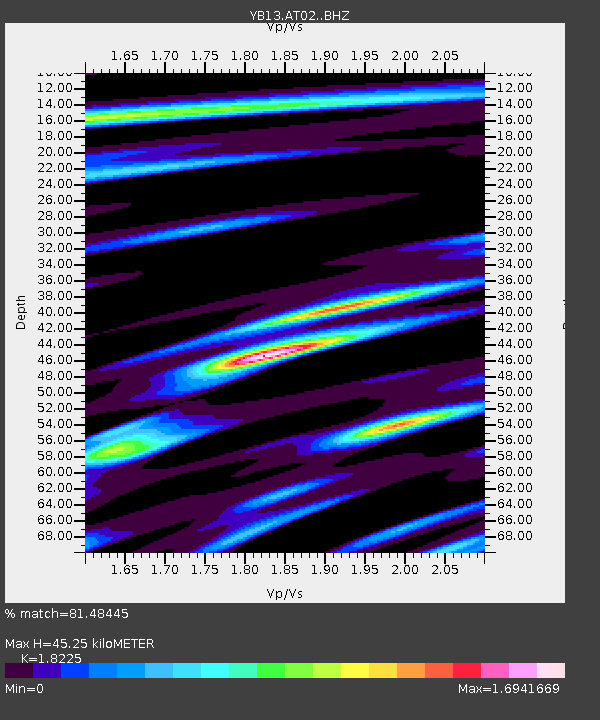
| Estimated Moho Depth: |
45.25 km |
| Estimated Crust Vp/Vs: |
1.82 |
| Assumed Crust Vp: |
6.35 km/s |
| Estimated Crust Vs: |
3.484 km/s |
| Estimated Crust Poisson's Ratio: |
0.28 |
|
| Radial Match: |
81.48445 % |
| Radial Bump: |
400 |
| Transverse Match: |
74.50402 % |
| Transverse Bump: |
400 |
| SOD ConfigId: |
3390531 |
| Insert Time: |
2019-04-12 03:37:48.479 +0000 |
| GWidth: |
2.5 |
| Max Bumps: |
400 |
| Tol: |
0.001 |
|

Signal To Noise
| Channel | StoN | STA | LTA |
| YB:AT02: :BHZ:20140601T10:16:50.899983Z | 6.9719634 | 5.20257E-7 | 7.4621305E-8 |
| YB:AT02: :BHN:20140601T10:16:50.899983Z | 1.2849091 | 6.731106E-8 | 5.2385854E-8 |
| YB:AT02: :BHE:20140601T10:16:50.899983Z | 3.412474 | 2.0559288E-7 | 6.024746E-8 |
| Arrivals |
| Ps | 6.1 SECOND |
| PpPs | 19 SECOND |
| PsPs/PpSs | 25 SECOND |


