You are here: Home > Network List > YB13 - Continental Dynamics/Cent. Anatolian Tectonics:Surface to Mantle Dynamics During Stations List
> Station AT02 Karatas,Sivas,Turkey > Earthquake Result Viewer
AT02 Karatas,Sivas,Turkey - Earthquake Result Viewer
| Earthquake location: |
South Indian Ocean |
| Earthquake latitude/longitude: |
-10.1/91.1 |
| Earthquake time(UTC): |
2014/06/14 (165) 11:11:00 GMT |
| Earthquake Depth: |
7.1 km |
| Earthquake Magnitude: |
6.4 MWP, 6.4 MWB |
| Earthquake Catalog/Contributor: |
NEIC PDE/NEIC COMCAT |
|
| Network: |
YB Continental Dynamics/Cent. Anatolian Tectonics:Surface to Mantle Dynamics During |
| Station: |
AT02 Karatas,Sivas,Turkey |
| Lat/Lon: |
39.38 N/37.06 E |
| Elevation: |
1532 m |
|
| Distance: |
70.2 deg |
| Az: |
318.204 deg |
| Baz: |
122.125 deg |
| Ray Param: |
0.055158377 |
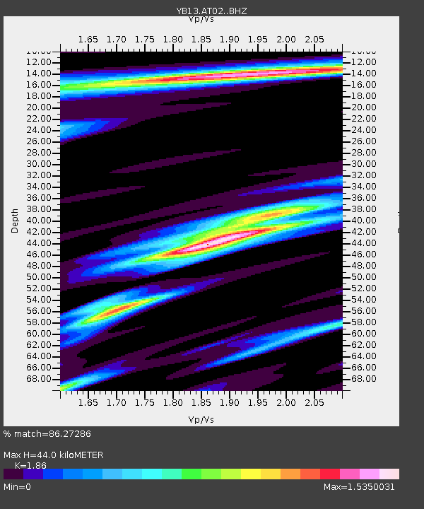
| Estimated Moho Depth: |
44.0 km |
| Estimated Crust Vp/Vs: |
1.86 |
| Assumed Crust Vp: |
6.35 km/s |
| Estimated Crust Vs: |
3.414 km/s |
| Estimated Crust Poisson's Ratio: |
0.30 |
|
| Radial Match: |
86.27286 % |
| Radial Bump: |
311 |
| Transverse Match: |
67.30694 % |
| Transverse Bump: |
400 |
| SOD ConfigId: |
3390531 |
| Insert Time: |
2019-04-12 06:29:58.072 +0000 |
| GWidth: |
2.5 |
| Max Bumps: |
400 |
| Tol: |
0.001 |
|

Signal To Noise
| Channel | StoN | STA | LTA |
| YB:AT02: :BHZ:20140614T11:21:43.080002Z | 14.329045 | 7.847667E-7 | 5.476755E-8 |
| YB:AT02: :BHN:20140614T11:21:43.080002Z | 1.5609267 | 1.3665677E-7 | 8.7548486E-8 |
| YB:AT02: :BHE:20140614T11:21:43.080002Z | 4.233315 | 2.2401485E-7 | 5.2917127E-8 |
| Arrivals |
| Ps | 6.2 SECOND |
| PpPs | 19 SECOND |
| PsPs/PpSs | 25 SECOND |


