You are here: Home > Network List > YB13 - Continental Dynamics/Cent. Anatolian Tectonics:Surface to Mantle Dynamics During Stations List
> Station AT02 Karatas,Sivas,Turkey > Earthquake Result Viewer
AT02 Karatas,Sivas,Turkey - Earthquake Result Viewer
| Earthquake location: |
Andaman Islands, India Region |
| Earthquake latitude/longitude: |
12.5/95.2 |
| Earthquake time(UTC): |
2014/09/26 (269) 04:21:24 GMT |
| Earthquake Depth: |
20 km |
| Earthquake Magnitude: |
5.5 MWC, 5.5 MWC |
| Earthquake Catalog/Contributor: |
NEIC PDE/NEIC COMCAT |
|
| Network: |
YB Continental Dynamics/Cent. Anatolian Tectonics:Surface to Mantle Dynamics During |
| Station: |
AT02 Karatas,Sivas,Turkey |
| Lat/Lon: |
39.38 N/37.06 E |
| Elevation: |
1532 m |
|
| Distance: |
57.6 deg |
| Az: |
308.78 deg |
| Baz: |
100.818 deg |
| Ray Param: |
0.06334092 |
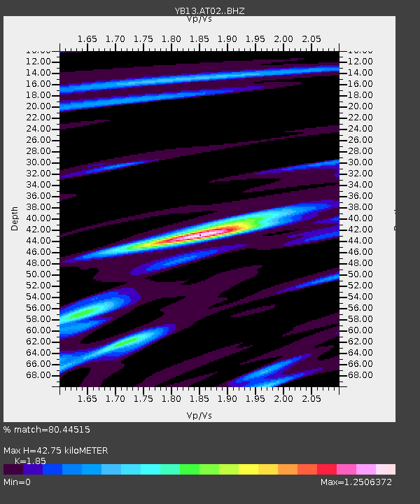
| Estimated Moho Depth: |
42.75 km |
| Estimated Crust Vp/Vs: |
1.85 |
| Assumed Crust Vp: |
6.35 km/s |
| Estimated Crust Vs: |
3.432 km/s |
| Estimated Crust Poisson's Ratio: |
0.29 |
|
| Radial Match: |
80.44515 % |
| Radial Bump: |
400 |
| Transverse Match: |
69.22024 % |
| Transverse Bump: |
380 |
| SOD ConfigId: |
3390531 |
| Insert Time: |
2019-04-14 05:51:01.125 +0000 |
| GWidth: |
2.5 |
| Max Bumps: |
400 |
| Tol: |
0.001 |
|

Signal To Noise
| Channel | StoN | STA | LTA |
| YB:AT02: :BHZ:20140926T04:30:41.460005Z | 2.9228997 | 2.1111926E-7 | 7.222939E-8 |
| YB:AT02: :BHN:20140926T04:30:41.460005Z | 0.82647157 | 5.997616E-8 | 7.256894E-8 |
| YB:AT02: :BHE:20140926T04:30:41.460005Z | 1.9795498 | 1.08334056E-7 | 5.4726616E-8 |
| Arrivals |
| Ps | 6.0 SECOND |
| PpPs | 18 SECOND |
| PsPs/PpSs | 24 SECOND |


