You are here: Home > Network List > YB13 - Continental Dynamics/Cent. Anatolian Tectonics:Surface to Mantle Dynamics During Stations List
> Station AT02 Karatas,Sivas,Turkey > Earthquake Result Viewer
AT02 Karatas,Sivas,Turkey - Earthquake Result Viewer
| Earthquake location: |
Northern Molucca Sea |
| Earthquake latitude/longitude: |
2.3/127.1 |
| Earthquake time(UTC): |
2014/11/21 (325) 10:10:19 GMT |
| Earthquake Depth: |
38 km |
| Earthquake Magnitude: |
6.5 MWC, 6.8 MI, 6.9 MI |
| Earthquake Catalog/Contributor: |
NEIC PDE/NEIC COMCAT |
|
| Network: |
YB Continental Dynamics/Cent. Anatolian Tectonics:Surface to Mantle Dynamics During |
| Station: |
AT02 Karatas,Sivas,Turkey |
| Lat/Lon: |
39.38 N/37.06 E |
| Elevation: |
1532 m |
|
| Distance: |
88.6 deg |
| Az: |
309.17 deg |
| Baz: |
88.248 deg |
| Ray Param: |
0.042434808 |
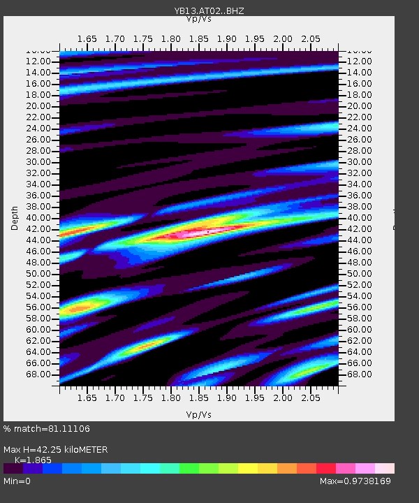
| Estimated Moho Depth: |
42.25 km |
| Estimated Crust Vp/Vs: |
1.87 |
| Assumed Crust Vp: |
6.35 km/s |
| Estimated Crust Vs: |
3.405 km/s |
| Estimated Crust Poisson's Ratio: |
0.30 |
|
| Radial Match: |
81.11106 % |
| Radial Bump: |
400 |
| Transverse Match: |
88.00838 % |
| Transverse Bump: |
400 |
| SOD ConfigId: |
3390531 |
| Insert Time: |
2019-04-15 03:40:28.962 +0000 |
| GWidth: |
2.5 |
| Max Bumps: |
400 |
| Tol: |
0.001 |
|

Signal To Noise
| Channel | StoN | STA | LTA |
| YB:AT02: :BHZ:20141121T10:22:37.499973Z | 19.52371 | 2.0889436E-6 | 1.0699521E-7 |
| YB:AT02: :BHN:20141121T10:22:37.499973Z | 1.4023343 | 1.6778434E-7 | 1.1964646E-7 |
| YB:AT02: :BHE:20141121T10:22:37.499973Z | 3.6563866 | 5.2274277E-7 | 1.4296704E-7 |
| Arrivals |
| Ps | 5.9 SECOND |
| PpPs | 19 SECOND |
| PsPs/PpSs | 25 SECOND |


