You are here: Home > Network List > YB13 - Continental Dynamics/Cent. Anatolian Tectonics:Surface to Mantle Dynamics During Stations List
> Station AT02 Karatas,Sivas,Turkey > Earthquake Result Viewer
AT02 Karatas,Sivas,Turkey - Earthquake Result Viewer
| Earthquake location: |
Rat Islands, Aleutian Islands |
| Earthquake latitude/longitude: |
51.9/179.6 |
| Earthquake time(UTC): |
2015/01/18 (018) 04:47:38 GMT |
| Earthquake Depth: |
106 km |
| Earthquake Magnitude: |
5.8 MB, 5.9 MB |
| Earthquake Catalog/Contributor: |
NEIC PDE/NEIC COMCAT |
|
| Network: |
YB Continental Dynamics/Cent. Anatolian Tectonics:Surface to Mantle Dynamics During |
| Station: |
AT02 Karatas,Sivas,Turkey |
| Lat/Lon: |
39.38 N/37.06 E |
| Elevation: |
1532 m |
|
| Distance: |
83.4 deg |
| Az: |
331.65 deg |
| Baz: |
22.308 deg |
| Ray Param: |
0.04598633 |
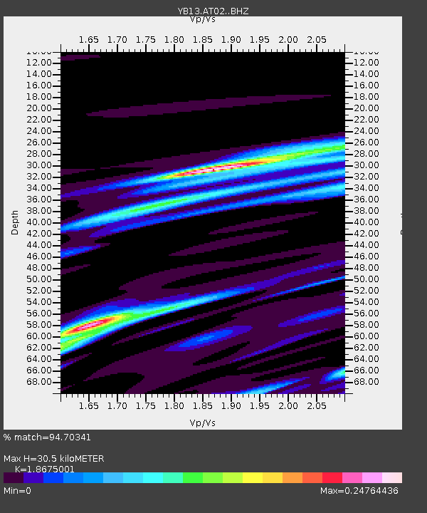
| Estimated Moho Depth: |
30.5 km |
| Estimated Crust Vp/Vs: |
1.87 |
| Assumed Crust Vp: |
6.35 km/s |
| Estimated Crust Vs: |
3.4 km/s |
| Estimated Crust Poisson's Ratio: |
0.30 |
|
| Radial Match: |
94.70341 % |
| Radial Bump: |
160 |
| Transverse Match: |
57.052258 % |
| Transverse Bump: |
400 |
| SOD ConfigId: |
3390531 |
| Insert Time: |
2019-04-16 02:30:11.688 +0000 |
| GWidth: |
2.5 |
| Max Bumps: |
400 |
| Tol: |
0.001 |
|

Signal To Noise
| Channel | StoN | STA | LTA |
| YB:AT02: :BHZ:20150118T04:59:22.60001Z | 2.5031185 | 2.1107428E-7 | 8.4324526E-8 |
| YB:AT02: :BHN:20150118T04:59:22.60001Z | 1.6471264 | 1.4043063E-7 | 8.525795E-8 |
| YB:AT02: :BHE:20150118T04:59:22.60001Z | 1.2269993 | 1.0487979E-7 | 8.547664E-8 |
| Arrivals |
| Ps | 4.3 SECOND |
| PpPs | 13 SECOND |
| PsPs/PpSs | 18 SECOND |


