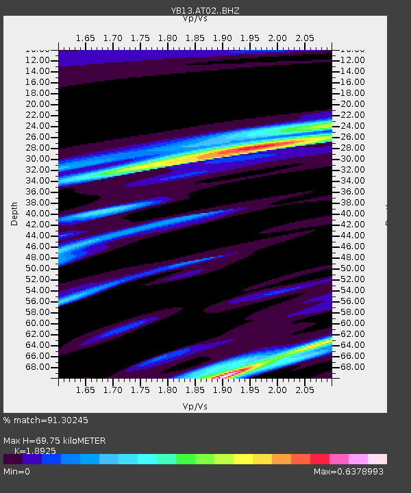
AT02 Karatas,Sivas,Turkey - Earthquake Result Viewer

Earthquake location: Off East Coast Of Honshu, Japan
Earthquake latitude/longitude: 39.6/143.6
Earthquake time(UTC): 2015/02/17 (048) 16:33:21 GMT
Earthquake Depth: 10 km
Earthquake Magnitude: 5.5 MWW, 5.5 MWC, 5.5 MWB
Earthquake Catalog/Contributor: NEIC PDE/NEIC COMCAT
Network: YB Continental Dynamics/Cent. Anatolian Tectonics:Surface to Mantle Dynamics During
Station: AT02 Karatas,Sivas,Turkey
Lat/Lon: 39.38 N/37.06 E
Elevation: 1532 m
Distance: 76.7 deg
Az: 310.217 deg
Baz: 49.598 deg
Ray Param: 0.05084003
Estimated Moho Depth: 69.75 km
Estimated Crust Vp/Vs: 1.89
Assumed Crust Vp: 6.35 km/s
Estimated Crust Vs: 3.355 km/s
Estimated Crust Poisson's Ratio: 0.31
Radial Match: 91.30245 %
Radial Bump: 200
Transverse Match: 49.483307 %
Transverse Bump: 389
SOD ConfigId: 7019011
Insert Time: 2019-04-16 21:52:01.700 +0000
GWidth: 2.5
Max Bumps: 400
Tol: 0.001

Signal To Noise

ChannelStoNSTALTA
YB:AT02: :BHZ:20150217T16:44:41.01998Z1.74245112.7205894E-71.5613577E-7
YB:AT02: :BHN:20150217T16:44:41.01998Z2.12843562.1371048E-71.00407306E-7
YB:AT02: :BHE:20150217T16:44:41.01998Z1.37117112.1171914E-71.5440753E-7
Arrivals
Ps10 SECOND
PpPs31 SECOND
PsPs/PpSs41 SECOND