You are here: Home > Network List > YB13 - Continental Dynamics/Cent. Anatolian Tectonics:Surface to Mantle Dynamics During Stations List
> Station AT02 Karatas,Sivas,Turkey > Earthquake Result Viewer
AT02 Karatas,Sivas,Turkey - Earthquake Result Viewer
| Earthquake location: |
Near East Coast Of Honshu, Japan |
| Earthquake latitude/longitude: |
40.1/142.9 |
| Earthquake time(UTC): |
2015/04/29 (119) 16:09:51 GMT |
| Earthquake Depth: |
34 km |
| Earthquake Magnitude: |
5.4 MW, 5.3 mb, 5.3 MS |
| Earthquake Catalog/Contributor: |
ISC/ISC |
|
| Network: |
YB Continental Dynamics/Cent. Anatolian Tectonics:Surface to Mantle Dynamics During |
| Station: |
AT02 Karatas,Sivas,Turkey |
| Lat/Lon: |
39.38 N/37.06 E |
| Elevation: |
1532 m |
|
| Distance: |
75.9 deg |
| Az: |
309.765 deg |
| Baz: |
49.558 deg |
| Ray Param: |
0.051282775 |
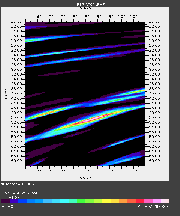
| Estimated Moho Depth: |
50.25 km |
| Estimated Crust Vp/Vs: |
1.88 |
| Assumed Crust Vp: |
6.35 km/s |
| Estimated Crust Vs: |
3.378 km/s |
| Estimated Crust Poisson's Ratio: |
0.30 |
|
| Radial Match: |
92.96615 % |
| Radial Bump: |
253 |
| Transverse Match: |
68.83193 % |
| Transverse Bump: |
400 |
| SOD ConfigId: |
7422571 |
| Insert Time: |
2019-04-18 14:29:58.897 +0000 |
| GWidth: |
2.5 |
| Max Bumps: |
400 |
| Tol: |
0.001 |
|

Signal To Noise
| Channel | StoN | STA | LTA |
| YB:AT02: :BHZ:20150429T16:21:03.400005Z | 5.0322537 | 2.4224448E-7 | 4.813837E-8 |
| YB:AT02: :BHN:20150429T16:21:03.400005Z | 3.2749147 | 1.6411884E-7 | 5.011393E-8 |
| YB:AT02: :BHE:20150429T16:21:03.400005Z | 1.6279625 | 8.722502E-8 | 5.357926E-8 |
| Arrivals |
| Ps | 7.2 SECOND |
| PpPs | 22 SECOND |
| PsPs/PpSs | 29 SECOND |


