You are here: Home > Network List > TA - USArray Transportable Network (new EarthScope stations) Stations List
> Station Z31A Sharp Cattle Ranch, Aspermont, TX, USA > Earthquake Result Viewer
Z31A Sharp Cattle Ranch, Aspermont, TX, USA - Earthquake Result Viewer
| Earthquake location: |
Near East Coast Of Honshu, Japan |
| Earthquake latitude/longitude: |
39.7/142.4 |
| Earthquake time(UTC): |
2010/07/04 (185) 21:55:51 GMT |
| Earthquake Depth: |
27 km |
| Earthquake Magnitude: |
6.4 MB, 6.1 MS, 6.3 MW, 6.2 MW |
| Earthquake Catalog/Contributor: |
WHDF/NEIC |
|
| Network: |
TA USArray Transportable Network (new EarthScope stations) |
| Station: |
Z31A Sharp Cattle Ranch, Aspermont, TX, USA |
| Lat/Lon: |
33.32 N/100.14 W |
| Elevation: |
547 m |
|
| Distance: |
87.2 deg |
| Az: |
48.049 deg |
| Baz: |
316.742 deg |
| Ray Param: |
0.043496836 |
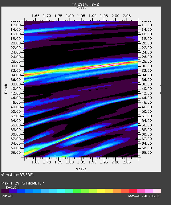
| Estimated Moho Depth: |
29.75 km |
| Estimated Crust Vp/Vs: |
1.94 |
| Assumed Crust Vp: |
6.426 km/s |
| Estimated Crust Vs: |
3.312 km/s |
| Estimated Crust Poisson's Ratio: |
0.32 |
|
| Radial Match: |
87.5381 % |
| Radial Bump: |
400 |
| Transverse Match: |
70.53744 % |
| Transverse Bump: |
400 |
| SOD ConfigId: |
319893 |
| Insert Time: |
2011-01-05 00:21:49.529 +0000 |
| GWidth: |
2.5 |
| Max Bumps: |
400 |
| Tol: |
0.001 |
|

Signal To Noise
| Channel | StoN | STA | LTA |
| TA:Z31A: :BHZ:20100704T22:08:04.12502Z | 12.978862 | 1.1888334E-6 | 9.1597656E-8 |
| TA:Z31A: :BHN:20100704T22:08:04.12502Z | 2.2700539 | 2.5578507E-7 | 1.1267798E-7 |
| TA:Z31A: :BHE:20100704T22:08:04.12502Z | 2.944876 | 4.254369E-7 | 1.4446682E-7 |
| Arrivals |
| Ps | 4.4 SECOND |
| PpPs | 13 SECOND |
| PsPs/PpSs | 18 SECOND |


