You are here: Home > Network List > US - United States National Seismic Network Stations List
> Station SDCO Great Sand Dunes National Park, Colorado, USA > Earthquake Result Viewer
SDCO Great Sand Dunes National Park, Colorado, USA - Earthquake Result Viewer
| Earthquake location: |
Vanuatu Islands |
| Earthquake latitude/longitude: |
-15.6/167.7 |
| Earthquake time(UTC): |
2007/08/01 (213) 17:08:51 GMT |
| Earthquake Depth: |
120 km |
| Earthquake Magnitude: |
6.2 MB, 7.2 MW, 7.2 MW |
| Earthquake Catalog/Contributor: |
WHDF/NEIC |
|
| Network: |
US United States National Seismic Network |
| Station: |
SDCO Great Sand Dunes National Park, Colorado, USA |
| Lat/Lon: |
37.75 N/105.50 W |
| Elevation: |
2569 m |
|
| Distance: |
96.9 deg |
| Az: |
52.874 deg |
| Baz: |
255.748 deg |
| Ray Param: |
0.04027203 |
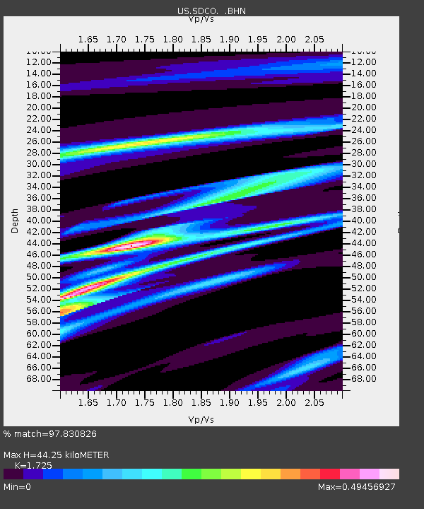
| Estimated Moho Depth: |
44.25 km |
| Estimated Crust Vp/Vs: |
1.73 |
| Assumed Crust Vp: |
6.316 km/s |
| Estimated Crust Vs: |
3.661 km/s |
| Estimated Crust Poisson's Ratio: |
0.25 |
|
| Radial Match: |
97.830826 % |
| Radial Bump: |
174 |
| Transverse Match: |
94.062645 % |
| Transverse Bump: |
365 |
| SOD ConfigId: |
2564 |
| Insert Time: |
2010-03-05 03:12:23.986 +0000 |
| GWidth: |
2.5 |
| Max Bumps: |
400 |
| Tol: |
0.001 |
|

Signal To Noise
| Channel | StoN | STA | LTA |
| US:SDCO: :BHN:20070801T17:21:37.704016Z | 0.510223 | 1.9578465E-8 | 3.837237E-8 |
| US:SDCO: :BHE:20070801T17:21:37.704016Z | 1.023734 | 3.9638913E-8 | 3.8719932E-8 |
| US:SDCO: :BHZ:20070801T17:21:37.704016Z | 2.081239 | 1.7961545E-7 | 8.630217E-8 |
| Arrivals |
| Ps | 5.2 SECOND |
| PpPs | 19 SECOND |
| PsPs/PpSs | 24 SECOND |


