You are here: Home > Network List > US - United States National Seismic Network Stations List
> Station SDCO Great Sand Dunes National Park, Colorado, USA > Earthquake Result Viewer
SDCO Great Sand Dunes National Park, Colorado, USA - Earthquake Result Viewer
| Earthquake location: |
Near Coast Of Northern Chile |
| Earthquake latitude/longitude: |
-27.2/-71.1 |
| Earthquake time(UTC): |
2006/04/30 (120) 21:40:58 GMT |
| Earthquake Depth: |
12 km |
| Earthquake Magnitude: |
5.9 MB, 6.7 MS, 6.5 MW, 6.3 ML |
| Earthquake Catalog/Contributor: |
WHDF/NEIC |
|
| Network: |
US United States National Seismic Network |
| Station: |
SDCO Great Sand Dunes National Park, Colorado, USA |
| Lat/Lon: |
37.75 N/105.50 W |
| Elevation: |
2569 m |
|
| Distance: |
72.2 deg |
| Az: |
331.914 deg |
| Baz: |
148.068 deg |
| Ray Param: |
0.053784188 |
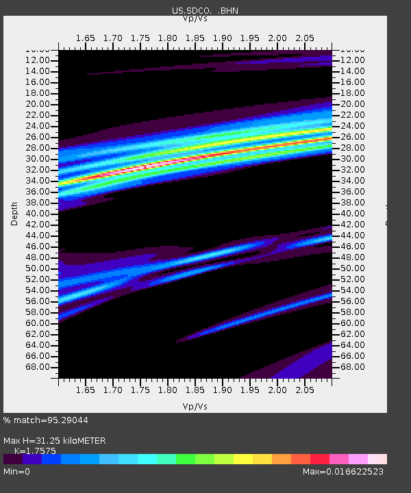
| Estimated Moho Depth: |
31.25 km |
| Estimated Crust Vp/Vs: |
1.76 |
| Assumed Crust Vp: |
6.316 km/s |
| Estimated Crust Vs: |
3.593 km/s |
| Estimated Crust Poisson's Ratio: |
0.26 |
|
| Radial Match: |
95.29044 % |
| Radial Bump: |
83 |
| Transverse Match: |
97.227486 % |
| Transverse Bump: |
57 |
| SOD ConfigId: |
2669 |
| Insert Time: |
2010-03-05 03:15:26.523 +0000 |
| GWidth: |
2.5 |
| Max Bumps: |
400 |
| Tol: |
0.001 |
|

Signal To Noise
| Channel | StoN | STA | LTA |
| US:SDCO: :BHN:20060430T21:51:52.135007Z | 0.84680265 | 1.8956996E-7 | 2.2386557E-7 |
| US:SDCO: :BHE:20060430T21:51:52.135007Z | 1.6497735 | 7.508718E-7 | 4.551363E-7 |
| US:SDCO: :BHZ:20060430T21:51:52.135007Z | 0.82796216 | 4.069543E-7 | 4.9151316E-7 |
| Arrivals |
| Ps | 3.9 SECOND |
| PpPs | 13 SECOND |
| PsPs/PpSs | 17 SECOND |


