You are here: Home > Network List > US - United States National Seismic Network Stations List
> Station SDCO Great Sand Dunes National Park, Colorado, USA > Earthquake Result Viewer
SDCO Great Sand Dunes National Park, Colorado, USA - Earthquake Result Viewer
| Earthquake location: |
Jujuy Province, Argentina |
| Earthquake latitude/longitude: |
-23.6/-66.9 |
| Earthquake time(UTC): |
2022/05/10 (130) 23:06:28 GMT |
| Earthquake Depth: |
235 km |
| Earthquake Magnitude: |
6.7 Mi |
| Earthquake Catalog/Contributor: |
NEIC PDE/at |
|
| Network: |
US United States National Seismic Network |
| Station: |
SDCO Great Sand Dunes National Park, Colorado, USA |
| Lat/Lon: |
37.75 N/105.50 W |
| Elevation: |
2569 m |
|
| Distance: |
71.0 deg |
| Az: |
328.46 deg |
| Baz: |
142.748 deg |
| Ray Param: |
0.05396194 |
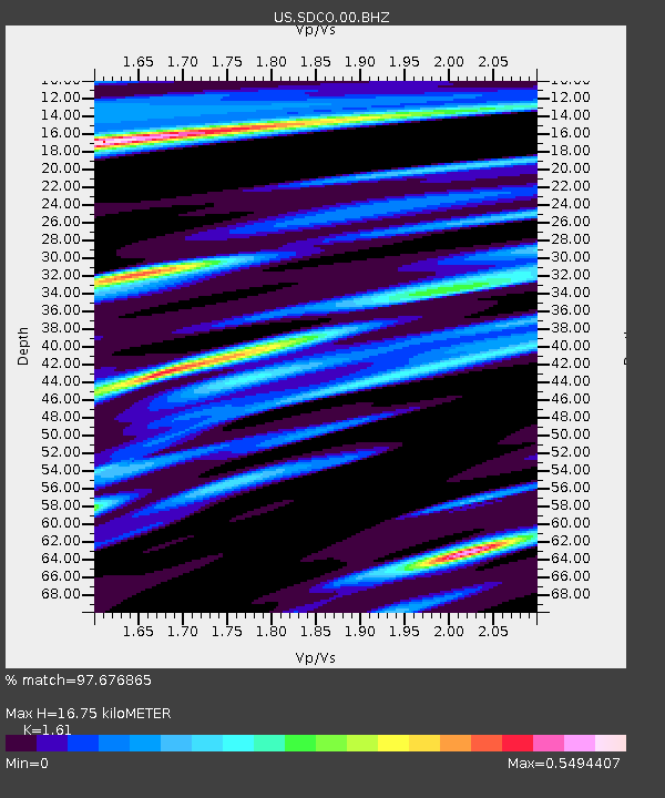
| Estimated Moho Depth: |
16.75 km |
| Estimated Crust Vp/Vs: |
1.61 |
| Assumed Crust Vp: |
6.316 km/s |
| Estimated Crust Vs: |
3.923 km/s |
| Estimated Crust Poisson's Ratio: |
0.19 |
|
| Radial Match: |
97.676865 % |
| Radial Bump: |
295 |
| Transverse Match: |
95.00618 % |
| Transverse Bump: |
373 |
| SOD ConfigId: |
27527651 |
| Insert Time: |
2022-05-24 23:23:55.481 +0000 |
| GWidth: |
2.5 |
| Max Bumps: |
400 |
| Tol: |
0.001 |
|

Signal To Noise
| Channel | StoN | STA | LTA |
| US:SDCO:00:BHZ:20220510T23:16:49.099976Z | 1.1417228 | 9.5056826E-8 | 8.325736E-8 |
| US:SDCO:00:BH1:20220510T23:16:49.099976Z | 1.3694667 | 1.213195E-7 | 8.858887E-8 |
| US:SDCO:00:BH2:20220510T23:16:49.099976Z | 1.8354613 | 2.0388076E-7 | 1.1107876E-7 |
| Arrivals |
| Ps | 1.7 SECOND |
| PpPs | 6.7 SECOND |
| PsPs/PpSs | 8.3 SECOND |


