You are here: Home > Network List > US - United States National Seismic Network Stations List
> Station SDCO Great Sand Dunes National Park, Colorado, USA > Earthquake Result Viewer
SDCO Great Sand Dunes National Park, Colorado, USA - Earthquake Result Viewer
| Earthquake location: |
Rat Islands, Aleutian Islands |
| Earthquake latitude/longitude: |
52.1/178.3 |
| Earthquake time(UTC): |
2022/06/04 (155) 23:38:12 GMT |
| Earthquake Depth: |
105 km |
| Earthquake Magnitude: |
6.3 mww |
| Earthquake Catalog/Contributor: |
NEIC PDE/us |
|
| Network: |
US United States National Seismic Network |
| Station: |
SDCO Great Sand Dunes National Park, Colorado, USA |
| Lat/Lon: |
37.75 N/105.50 W |
| Elevation: |
2569 m |
|
| Distance: |
53.4 deg |
| Az: |
73.537 deg |
| Baz: |
311.69 deg |
| Ray Param: |
0.06579628 |
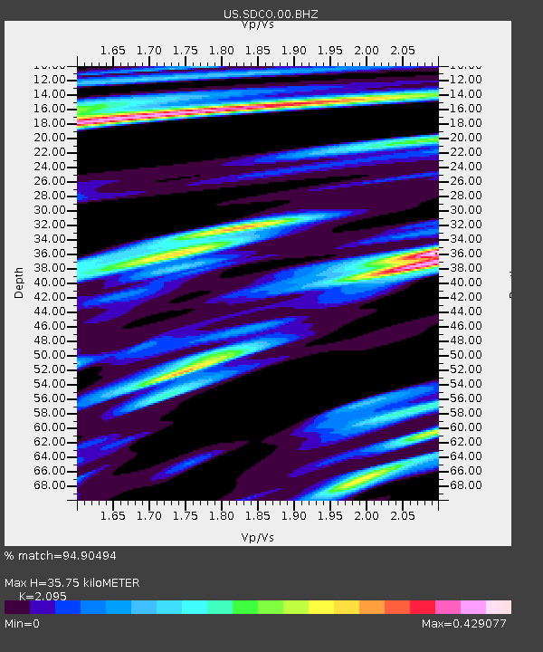
| Estimated Moho Depth: |
35.75 km |
| Estimated Crust Vp/Vs: |
2.10 |
| Assumed Crust Vp: |
6.316 km/s |
| Estimated Crust Vs: |
3.015 km/s |
| Estimated Crust Poisson's Ratio: |
0.35 |
|
| Radial Match: |
94.90494 % |
| Radial Bump: |
309 |
| Transverse Match: |
90.306885 % |
| Transverse Bump: |
373 |
| SOD ConfigId: |
28208852 |
| Insert Time: |
2022-06-27 16:27:28.562 +0000 |
| GWidth: |
2.5 |
| Max Bumps: |
400 |
| Tol: |
0.001 |
|

Signal To Noise
| Channel | StoN | STA | LTA |
| US:SDCO:00:BHZ:20220604T23:46:50.700028Z | 14.584453 | 1.6963396E-6 | 1.163115E-7 |
| US:SDCO:00:BH1:20220604T23:46:50.700028Z | 5.4103093 | 3.4391985E-7 | 6.3567505E-8 |
| US:SDCO:00:BH2:20220604T23:46:50.700028Z | 8.43904 | 8.552065E-7 | 1.0133931E-7 |
| Arrivals |
| Ps | 6.5 SECOND |
| PpPs | 17 SECOND |
| PsPs/PpSs | 23 SECOND |


