You are here: Home > Network List > TX - Texas Seismological Network Stations List
> Station MB25 Gardendale > Earthquake Result Viewer
MB25 Gardendale - Earthquake Result Viewer
| Earthquake location: |
Mariana Islands |
| Earthquake latitude/longitude: |
19.1/145.4 |
| Earthquake time(UTC): |
2024/04/05 (096) 11:03:16 GMT |
| Earthquake Depth: |
222 km |
| Earthquake Magnitude: |
6.8 mww |
| Earthquake Catalog/Contributor: |
NEIC PDE/us |
|
| Network: |
TX Texas Seismological Network |
| Station: |
MB25 Gardendale |
| Lat/Lon: |
32.03 N/102.49 W |
| Elevation: |
921 m |
|
| Distance: |
97.5 deg |
| Az: |
52.529 deg |
| Baz: |
297.926 deg |
| Ray Param: |
0.039985087 |
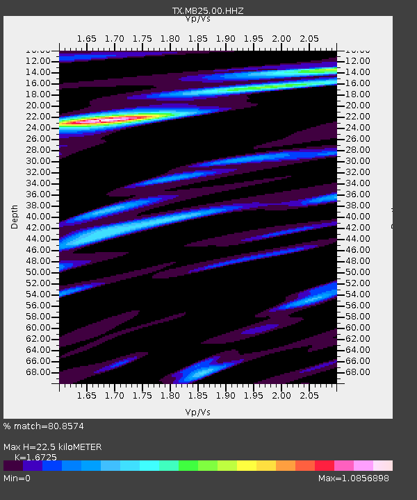
| Estimated Moho Depth: |
22.5 km |
| Estimated Crust Vp/Vs: |
1.67 |
| Assumed Crust Vp: |
6.129 km/s |
| Estimated Crust Vs: |
3.665 km/s |
| Estimated Crust Poisson's Ratio: |
0.22 |
|
| Radial Match: |
80.8574 % |
| Radial Bump: |
347 |
| Transverse Match: |
70.53518 % |
| Transverse Bump: |
400 |
| SOD ConfigId: |
34025071 |
| Insert Time: |
2024-04-19 11:36:49.492 +0000 |
| GWidth: |
2.5 |
| Max Bumps: |
400 |
| Tol: |
0.001 |
|

Signal To Noise
| Channel | StoN | STA | LTA |
| TX:MB25:00:HHZ:20240405T11:15:53.42099Z | 21.112097 | 4.382452E-6 | 2.0758013E-7 |
| TX:MB25:00:HHN:20240405T11:15:53.42099Z | 1.5809592 | 5.453067E-7 | 3.4492143E-7 |
| TX:MB25:00:HHE:20240405T11:15:53.42099Z | 6.609642 | 9.905306E-7 | 1.4986146E-7 |
| Arrivals |
| Ps | 2.5 SECOND |
| PpPs | 9.6 SECOND |
| PsPs/PpSs | 12 SECOND |


