You are here: Home > Network List > US - United States National Seismic Network Stations List
> Station SDCO Great Sand Dunes National Park, Colorado, USA > Earthquake Result Viewer
SDCO Great Sand Dunes National Park, Colorado, USA - Earthquake Result Viewer
| Earthquake location: |
Eastern Siberia, Russia |
| Earthquake latitude/longitude: |
67.6/142.5 |
| Earthquake time(UTC): |
2013/02/14 (045) 13:13:53 GMT |
| Earthquake Depth: |
11 km |
| Earthquake Magnitude: |
6.5 MB, 6.7 MS, 6.6 MW, 6.7 MW |
| Earthquake Catalog/Contributor: |
WHDF/NEIC |
|
| Network: |
US United States National Seismic Network |
| Station: |
SDCO Great Sand Dunes National Park, Colorado, USA |
| Lat/Lon: |
37.75 N/105.50 W |
| Elevation: |
2569 m |
|
| Distance: |
63.3 deg |
| Az: |
55.374 deg |
| Baz: |
336.589 deg |
| Ray Param: |
0.05967358 |
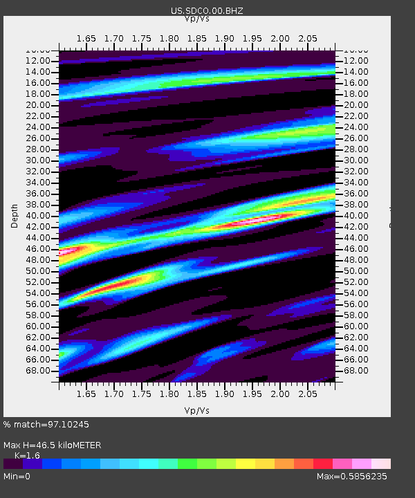
| Estimated Moho Depth: |
46.5 km |
| Estimated Crust Vp/Vs: |
1.60 |
| Assumed Crust Vp: |
6.316 km/s |
| Estimated Crust Vs: |
3.947 km/s |
| Estimated Crust Poisson's Ratio: |
0.18 |
|
| Radial Match: |
97.10245 % |
| Radial Bump: |
302 |
| Transverse Match: |
93.74176 % |
| Transverse Bump: |
347 |
| SOD ConfigId: |
558545 |
| Insert Time: |
2013-09-18 07:23:20.566 +0000 |
| GWidth: |
2.5 |
| Max Bumps: |
400 |
| Tol: |
0.001 |
|

Signal To Noise
| Channel | StoN | STA | LTA |
| US:SDCO:00:BHZ:20130214T13:23:50.624019Z | 19.272106 | 2.3562618E-6 | 1.222628E-7 |
| US:SDCO:00:BH1:20130214T13:23:50.624019Z | 7.9832277 | 7.955597E-7 | 9.965388E-8 |
| US:SDCO:00:BH2:20130214T13:23:50.624019Z | 9.998486 | 7.852711E-7 | 7.8539E-8 |
| Arrivals |
| Ps | 4.6 SECOND |
| PpPs | 18 SECOND |
| PsPs/PpSs | 23 SECOND |


